Tag Archives: boating

California Delta Water Diversion Update

Picture courtesy of the California Department of Water Resources

Delta–Picture courtesy of the California Department of Water Resources

Water Fraud Update

By Bill Wells

The Santa Clara Valley Water District voted 4-3 to use $650 million of their ratepayer’s money to help fund the Brown / Laird twin tunnel WaterFraud.  A joint powers authority, the Delta Conveyance Design and Construction Authority has been created to oversee the final design and  of the tunnels.  I am sure nothing can go wrong with that.  So far Metropolitan Water District of Southern California, Kern County Water Authority, and Contra Costa Valley Water District have committed a total of about $12.5 billion of their ratepayer’s money leaving it about $42.5 billion short if you use Arnold Schwarzenegger’s $55 billion estimate of the cost of the project.


Governor Brown is quoted as saying: “the only time you get anything done with water is when a Brown is governor and there are no more Browns coming along so you better get it done.  I can tell you if I wasn’t pushing this thing it wouldn’t be going anywhere.  If it doesn’t make it this time forget it.  You will all be dead before it is even thought of again.”  I am confident this mother of all boondoggles can be stopped if enough good people stand up against it.  The California Department of Water Resources has proven over and over again that they don’t understand and can not manage a project like this.  The state Waterboard hearings are available on YouTube, when you have some spare time listen to the states attorneys’ presentations and  draw your own conclusions.  You will note too in unintentional irony that the states lead attorney Tripp Mizzel bears a resemblance to the Roman Polanski character in the film Chinatown.

Continue reading California Delta Water Diversion Update

Boating On The California Delta

San Joaquin Yacht Club at Bethel Island
San Joaquin Yacht Club at Bethel Island Photo Credit: Bill Wells

By Bill Wells

Every year in the spring when the weather turns warmer and the rains subside, thoughts turn to boating in the Delta. Certainly there are many diehard boaters about in the winter months too, but the advent of spring brings them out in force. Most resorts and restaurants that close for a winter vacation reopen in mid – April and opening day of yachting parades are scheduled all around the Delta and San Francisco Bay area.

The term “opening day” was coined in 1903 when the drawbridge in Belvedere was opened to let the “arcs” or houseboats travel from Belvedere Lagoon to their summer location in Belvedere Cove. Since then the various yacht clubs have called the beginning of yachting season in the area “opening day.”

Korths Pirates Lair & Delta Loop
Korths Pirates Lair & Delta Loop Photo Credit: Bill Wells

Opening day parades are held all over the Delta during April with major parades sponsored by the Stockton Yacht Club, Sacramento Yacht Club and the San Joaquin Yacht Club. You don?t need to be a club member to participate in a parade with your boat. You contact the sponsoring club to register beforehand and generally there is a small fee to cover administrative expenses.

No boat? No problem! There are many shore side venues where you can watch the parades as they pass by.After the opening day celebrations, boating season begins in earnest. By mid-May the weather is generally consistently warm and there are parties and events all over the Delta every weekend from Memorial Day through Labor Day.

Barron Hilton has been sponsoring a fireworks display at Venice Island on the San Joaquin River for more than 50 years. Hilton explains that he originally started setting off fireworks for his children at his duck club. “I began shooting rockets and fountains on the levee for the benefit of my eight children,” he said. “I noticed that four or five boats stopped by to watch, then a dozen the next year, and about three times that number the third year. From there, it just seemed to grow like an amoeba.”

Today, Hilton produces a 30 minute show, choreographed to patriotic music, and fired by professional technicians from Pyro Spectaculars.

Bill Dutra of the Dutra Group provides a barge that serves as a floating launching pad for the fireworks. Even though the fireworks show itself only lasts a half hour, the boats start arriving for the event weeks beforehand. Many people anchor their yacht near the island and use their shore boats to commute to work at their area jobs. The thousands of boats are grouped so that there are pathways to travel between boats and many groups secure the same space year after year.

Later in July local folk head to Village West Marina in Stockton for the annual “Taste of the Delta” event. This is a strolling wine and food tasting showcasing Delta area wineries and restaurants. It is accessible by boat (or car) and is a very popular event, one of the many available to boaters in the Delta. With almost 60,000 acres of water and 1,000 miles of waterways, the Delta fun never ends.

Written by Bill Wells, Executive Director,
California Delta Chambers & Visitor’s Bureau


For all your real estate needs
Email or call today:

John J. O’Dell Realtor® GRI
Civil Engineer
General Contractor
(530) 263-1091
Email jodell@nevadacounty.com

DRE#00669941

Enhanced by Zemanta

Bullards Bar Reservoir & Emerald Cove Marina, Dobbins, California

Emerald Cove Marina - photo courtesy of Emerald Cove Marina
Emerald Cove Marina – photo courtesy of Emerald Cove Marina

Bullards Bar Reservoir is not in Nevada County, but it is close enough to Nevada City and Grass Valley as to make it a destination for water skiing, house boating and fishing. It’s only 21 miles north of Nevada City off of Highway 49 in the historic gold country. The three closest cities are Nevada City, Grass Valley and Marysville.

The lake surface is at 2,000 foot elevation, 16 miles long with about 60 miles of shoreline. The boating surface is 4,700 acres, which is a lot of area to boat in. There are only two launch ramps and once you are in the water, you are surrounded by a greenbelt covered with pine, oak, fir, madrone, dogwood and other species of trees native to the area. As you cruise up into the North Yuba Canyon, sheer cliffs of granite come down to greet the crystal clear water.

The North Yuba River is backed up by New Bullards Bar Dam which is an awesome sight all by itself. Standing 645? above the canyon floor, it holds back 960,000 acre feet of water. It’s the second tallest dam in California, 5th tallest in the United States. A hydro-electric dam, Bullards Bar Dam is operated and controlled by the Yuba County Water Agency. They are able to manage the water so that recreation access to the reservoir is never restricted.

Bullards Bar offers boat access campgrounds, land based sites, and shoreline camping permits. There are a total of only 160 sites, which limits the amount of people the area can accommodate. Emerald Cove Marina takes site specific reservations for all camping.

For the fisherman, there are kokanee salmon, rainbow trout, German browns, large mouth, small mouth and black bass, crappie, catfish, and bluegill. Bullards Bar has a reputation as having the best kokanee salmon and black bass fishing in California.

CAMPING
Campgrounds – Call for reservations & fees
Pets, NO Hookups, Boat & Trailer Storage, Some Flush Toilets

BOATING
Power, Row, Jet ski, Windsurf, Canoe, Sail, Water-ski, and Inflatables are allowed.
There is a full service marina with gas and propane exchange available
Rentals: Houseboats, Ski Boats, Jet Skis, and Pontoon Patio Boats

RECREATION
Fishing
Swimming, Picnicking, & Hiking
Snacks, Groceries, Bait & Tackle and Fuel Dock

For further information and reservations contact   Emerald Cove Marina (530) 692-3200

View Larger Map
For all your real estate needs, call or email:

John J. O’Dell Realtor® GRI
Real Estate Broker
O’Dell Realty
(530) 263-1091
jodell@nevadacounty.com

Inside a Russian Billionaire’s $300 Million Yacht

Known as the “A” — the mega-yacht features luxuries most of us can hardly dream up, like a glass-bottomed pool built atop a disco or a plush room with walls covered in stingray hides.

The boat, designed to be longer than a football field by the legendary French designer Phillipe Starck, cost $300 million to build.

“The design is unique, it’s not beautiful but it’s interesting,” observed Norm Ronnenberg, a maritime lawyer in the Bay Area. ( I don’t know if he is jealous, but I think it’s beautiful )

Among other extravagances, the ship has a $60,000 bannister, a master bedroom that opens only to a fingerprint and a secret room designated specifically for “nookie.”

The yacht’s owner is Andrey Melinchenko, a 38-year-old Russian businessman who made his money in banking, fertilizer and coal. Forbes magazine currently puts Melinchenko’s net worth at $4.4 billion.

Wall Street Journal’s ‘s Robert Frank takes an exclusive tour of Andrey Melnichenko’s 394-foot mega-yacht.

Scotts Flat Lake Level Drops

Scotts-Flat-Lake-fall-2009

September 28, 2009

As you can see from the picture I took from my deck last Saturday morning, Scotts Flat Lake is down to its usual fall levels. On May of this year, the water level was at around elevation 3,070. Nevada Irrigation District chart shows that it contained 500,000 acre feet of water. (An acre foot is one foot of water spread over one acre or 43,560 cubic feet of water) NID estimates that the water level is now at 3,046 feet with about 300,000 acre feet of water.

Looking north at Cascade Shores Campgrounds & boat moorings

Most if not all of the boats which were moored on the north side of the lake are gone.  Scotts Flat Lake is known for sailing  and most of the boats that were moored in the lake were fairly large sail boats. You can get the rates for mooring on the lake during the boating season by calling NID at (530) 273-6185. If you are interested, I suggest you call now, since most of the moorings are grabbed up early, way before the boating season starts. By the way, my house is in Cascade Shores at an elevation of 3,700 feet.

Collins Lake, Oregon House, California

Collins Lake Marina
Collins Lake Marina

Although Collins Lake Recreational Area is not in Nevada County, it is close enough to our area to be considered a great place to go fishing, boating or camping. Collins Lakes sits at an elevation of 1,200 with a surface area of over 1,000 acres with 12 miles of shoreline.

There are many activities at Collins Lake; which include:

Water skiing, tube or wakeboard are allowed. The water ski season begins May 1st and ends October 15th of each year. However, small, personal watercraft such as jet-skis and small personal watercraft are not permitted to operate on Collins Lake. Boat rentals are available. Of course, swimming is allowed, with the surface temperature of the clear water hovering around 75F to 78F degrees in the summer.

Camping facilities are available, along with cabins in addition to 150 campsites with hookups and 30 campsites without hookups.

Collins Lake Camp Site

The most noted feature of Collins Lake is its fishing. They are raising trophy rainbow trout in underwater net pens during the winter and releasing them in late spring. There are a total of 12 pens, each about the size of a bedroom (12’x 10’x 12′) which is located at the marina. These same trout are expected to triple in size to become 3 to 4 pound trophy-sized fish when released in spring time.

Not only that, they already have California’s largest trout stocking program north of Sacramento and have constructed net pens that will further increase this successful program. For every plant of rainbow trout normally received from Fish and Game, Collins Lake purchases 3 plants of larger trophy sized trout from private hatcheries. In 2007, there were a total of 28,000 pounds of trout planted. The average size of trophy trout planted each week during the spring was 2 to 6 pounds, with some whoppers topping 10 pounds! They are also famous for trophy trout and bass fishing.

For contact information and reservations call 800-286-0576 and locally 530-692-1600

Their website is at Collins Lake


View Larger Map

Lake Spaulding & High Sierra Lakes

Lake Spaulding
Lake Spaulding

Nevada County has numerous lakes. Most of them are located in the high country between Nevada City and the City of Truckee. Some of these lakes are; Toll house Lake, French Lake, Lake Spaulding, Webber Lake, White Rock Lake and there are more! Many of the lakes were formed by ancient glaciers that are now long gone.

A few of the lakes provide hydroelectric power and is managed by Pacific Gas & Electric. Those owned by P.G.&E are used for hydroelectric power and the company provides camping grounds and picnic facilities. One of these is Lake Spaulding which sits at an elevation of 5,014 feet. It has a surface area of 698 acres surrounded by a high alpine forest. (Google Maps shows Lake Spaulding as Fordyce Creek)

The history of the lake is that it was built for hydraulic mining in 1912. Hydraulic mining generated millions of dollars in tax revenues but was an environmental disaster. Millions of tons of earth and water were delivered to mountain streams that fed rivers flowing into the Sacramento Valley. Once the rivers reached the relatively flat valley, the water slowed, the rivers widened, and the sediment was deposited in the floodplains and river beds causing them to rise, shift to new channels, and overflow their banks, causing major flooding, especially during the spring melt. The end came on January 7, 1884, Judge Lorenzo Sawyer ruled on the matter. – no more dumping of mining debris where it could reach farmlands or navigable rivers.

Lake Spaulding has 25 developed camp sites for tents and RV’s. Boating is allowed, including power, row boats, jet ski, windsurf, canoe, sail, water-ski and inflatable’s. However, check with P.G. & E. before you go up there, since rules and regulations change from time to time. This is also an area for fishing which include brown and rainbow trout. There is also swimming, picnicking, hiking and backpacking.

For reservations and further information, contact P.G.& E. Regional Land Department (916) 386-5164

Let me know if you can add to the above information, use the contact form and I’ll contact you.


View Larger Map

Lake Englebright in Nevada-Yuba County

lake-englebright2

Englebright Lake offers a great deal of recreation including boating, camping and fishing. It’s located in Nevada-Yuba Counties, California. The lake was named after Harry Lane Englebright (January 2, 1884-May 13, 1943) who was a politician that served in the United States House of Representatives. He was a House minority whip between 1933 and 1943.  He was a mining engineer prior to entering politics in 1926 and was reelected every two years for the rest of his life.

Englebright Dam is a concrete arch structure and was constructed for the storage of hydraulic gold mining debris. The dam spans 1,142 feet across and is 260 feet high. The dam is in the steep Yuba River gorge known as the Narrows, holding back a 9 mile long lake with a surface area of 815 acres. It has 24 miles of shoreline and is at an elevation of 527 feet.

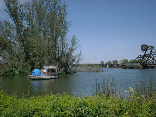
The shoreline is rocky and steep, with some areas of sandy beaches with pines and oaks.

lake-englebright1

Operating Hours:

Office hours are Monday – Friday 8:00 a.m. – 4:00 p.m. The park is open all year.

Camping:

Camping at Englebright Lake is unique as all campsites are boat-in only and located along the lake’s 24 miles of shoreline. Each campsite consists of a table, fire grill, lantern hanger and level spot for tents. Portable restrooms are centrally located in all campgrounds. Drinking water is available near each launch ramp.

Group Camping: (reservations required)

Point Defiance Recreation Area features a group campground that is available by reservation only. To help protect our natural resources, groups are limited to 50 people. Call the park office for reservations.

Boating:

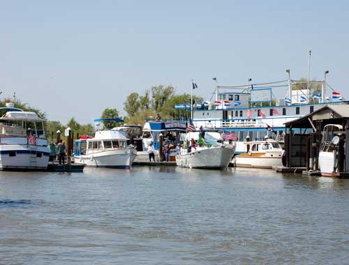
The lake provides plenty of space for the boating enthusiast, water skier or angler. Boats can be launched from one of two boat ramps located near the park’s entrance. Due to narrow canyons and sharp bends, the upper 4 miles of the lake are not suitable for waterskiing and/or towing any type of inflatable device. Therefore, these activities are restricted to the lower five miles of the lake. A counter-clockwise direction of travel is strictly enforced for the safety of park visitors. Types of boating allowed, power, row, Jet Ski, windsurf, canoe, sail, water ski, house, and inflatable’s are allowed. There is a full service marina with launch ramps. Rentals: fishing, canoe, water ski boats, houseboats & patio boats. There are also docks, berths, moorings and gas.

Fishing:

To the expert or beginning angler, Englebright means fish. Game fish such as rainbow and brown trout, large and smallmouth bass and Kokanee salmon abound in the lake’s clear, cool water. Catfish and sunfish can also be caught. Fish may be taken from the shore or boat by bottom fishing or trolling with bright, flashy lures.

Day Use:

Picnic facilities are available at the Narrows Recreation Area. Each site has a picnic table, barbeque grill and lawn area. Enjoy a short scenic hike to the dam overlook area or along the less strenuous fishing access trail.

Ranger Programs:Group tours and ranger programs can be scheduled by calling 530-432-6427.
Boat-in Camping: (first-come first-served basis)


Contacts:
U.S. Army Corps of Engineers
P.O. Box 6
Smartville, CA 95977-0006
(530) 432-6427 or fax (530) 432-6418
Email: englebright-info@usace.army.mil

Skippers Cove Marina  (530) 432-6302 offers boat  rentals, mooring, gas, sewage pumping and store facilities.

Additional information on the amount of settlement from the gold mining days and run off are available by a recent study made by the USGS at
Bathymetric and geophysical surveys of Englebright Lake

Bullards Bar Lake, Dobbins, California

Emerald Cove Marina - photo courtesy of Emerald Cove Marina

While Bullards Bar Lake is not in Nevada County, it is close enough to Nevada City and Grass Valley as to make it a designation for water skiing, house boating and fishing. It’s only 21 miles north of Nevada City off of Highway 49 in the historic gold country. The two closest cities are Nevada City, Grass Valley and Marysville.

The lake surface is at 2,000 foot elevation, 16 miles loan with about 60 miles of shoreline. The boating surface is 4,700 acres, which is a lot of area to boat in. There are only two launch ramps and once you are in the water, you are surrounded by a greenbelt covered with pine, oak, fir, madrone, dogwood and other species of trees native to the area. As you cruise up into the North Yuba Canyon, sheer cliffs of granite come down to greet the crystal clear water.

The North Yuba River is backed up by Bullards Bar Dam which is an awesome sight all by itself. Standing 645′ above the canyon floor, it holds back 960,000 acre feet of water. It’s the second tallest dam in California, 5th tallest in the United States. A hydro-electric dam, Bollards’ Bar Dam is operated and controlled by the Yuba County Water Agency. They are able to manage the water so that recreation access to the reservoir is never restricted.

Bullards Bar offers boat access campgrounds, land based sites, and shoreline camping permits. There are a total of only 160 sites, which limits the amount of people the area can accommodate. Emerald Cove takes site specific reservations for all camping.

For the fisherman, there are kokanee salmon, rainbow trout, german browns, largemouth, smallmouth and black bass, crappie, catfish, and bluegill. Bullards Bar has a reputation as having the best kokanee salmon fishing in California.

CAMPING
39 Boat access campgrounds – Call for reservations & fees
Pets, Full Hookups, RV & Trailer Storage, Disposal Station, Flush Toilets

BOATING
Power, Row, Jet ski, Windsurf, Canoe, Sail, Water-ski, and Inflatables are allowed.
There is a full service marina with gas and propane available
Rentals: Fishing Boats with Motors, House Boats

RECREATION
Fishing
Swimming, Picnicking, & Hiking
Snack Bar, Groceries, Bait & Tackle

For further information and reservations contact   Emerald Cove Resort and Marina (530) 692-3200


View Larger Map


Enhanced by Zemanta

Scotts Flat Lake, Nevada City, CA

Scotts Flat Lake picture from my deck March 21, 2009

My house overlooks Scotts Flat Lake and as you can see in the picture above, I get a really beautiful view of the lake . It’s a wonderful experience living above such a body of water, which is constantly changing appearance, either due to wind or other forces of nature. At times I can look out and see fog completely covering the lake, at other times; wind plays with the water and makes designs that are captivating to the eye and imagination. The lake is large enough for fairly large sail boats (my daughter had a 25 foot long sail boat that she sailed on the lake and there are  larger sail boats that use the lake), along with ski boats, canoes and small boats for fishing.

Scotts Flat Lake is at 3,100 feet in elevation and has a surface area of 850 acres with 7.5 miles of shoreline lined with a forest of pine trees. There are two launch ramps, a marina, campsites, a picnic area, sandy beaches and a general store. (My house is at 3,700 foot elevation.)

Looking at far side of Scotts Flat Lake, boat ramp and camp ground area. Notice the wind patterns

The fish in the lake are German Brown Trout, Massachusetts Brown Trout, Rainbow Trout, Kokanee, Large Mouth Bass, Small Mouth Bass, Bullhead Catfish and Channel Catfish. There are sites that are available for camping at Gate 1 with nightly single sites, and (1) one hundred person group site, Gate 2 has seventy five single sites and three group sites, one hosts twenty, one hosts thirty and  the third one hosts forty people.

Showers and flush toilets are available, along with multiple RV sites, but no RV hookupsare available. However, they do have dumping facilities for RV’s. You can bring pets, however they must be leashed at all times and they are not allowed along the beach or swim areas.

Below Scotts Flat Lake is Lower Scotts Flat, also called Deer Creek Reservoir which is much smaller than the upper lake. The only water craft I’ve seen here are mainly canoes and a few small boats for fishing.

For more information and to make reservations for camping follow this link Scotts Flat Lake Reservations

For a map of the lake follow this link Map of Scotts Flat Lake