Tag Archives: United States Forest Service

66 Million Trees are Dead in the Sierra Nevada Forest

Pine trees killed by bark beetles.
Pine trees killed by bark beetles. Little York Close cul-de sac

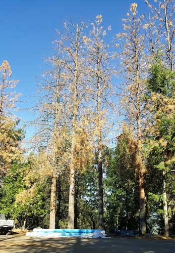
I’ve noticed with great alarm the number of trees dying from the drought and beetle infestation here in Nevada County  It seems like every day, while driving around the county, I see another group of pine trees dying or dead.

There is a small about 1,000 foot long cul-de-sac near my house. I counted 27 pine trees dead or dying in that cul-de-sac.   According to various sources  we have 66 million trees that are dead from the drought and the number is growing. Pine beetles of different varieties are to blame and the principal species which are responsible are: mountain pine beetle, fir engraver beetle, western pine beetle, Jeffrey pine beetle and pine engraver beetles.


Mountain pine beetle, about the size of a grain of rice.

The following is an excerpt from the National Forest Service

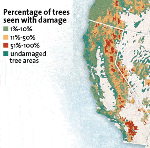
The U.S. Forest Service today announced that it has identified an additional 26 million trees dead in California since October 2015. These trees are located in six counties across 760,000 acres in the southern Sierra Nevada region of the state, and are in addition to the 40 million trees that died statewide from 2010 to October 2015, bringing the total to at least 66 million dead trees. Four consecutive years of severe drought in California, a dramatic rise in bark beetle infestation and warmer temperatures are leading to historic levels of tree die-off.

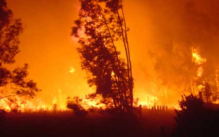
“Tree dies-offs of this magnitude are unprecedented and increase the risk of catastrophic wildfires that puts property and lives at risk,” said Agriculture Secretary Tom Vilsack. “While the fire risk is currently the most extreme in California because of the tree mortality, forests across the country are at risk of wildfire and urgently need restoration requiring a massive effort to remove this tinder and improve their health. Unfortunately, unless Congress acts now to address how we pay for firefighting, the Forest Service will not have the resources necessary to address the forest die-off and restore our forests. Forcing the Forest Service to pay for massive wildfire disasters out of its pre-existing fixed budget instead of from an emergency fund like all other natural disasters means there is not enough money left to do the very work that would help restore these high mortality areas. We must fund wildfire suppression like other natural disasters in the country.”

Between 2010 and late 2015, Forest Service aerial detection surveys found that 40 million trees died across California – with nearly three quarters of that total succumbing to drought and insect mortality from September 2014 to October 2015 alone. The survey identified approximately 26 million additional dead trees since the last inventory in October, 2015. The areas surveyed in May covered six southern Sierra counties including Fresno, Kern, Madera, Mariposa, Tuolumne and Tulare. Photos and video of the May survey are available on the Forest Service multimedia webpage.

Help keep this website going

Contact us: O’Dell Realty
530-263-1091

Error: Contact form not found.


Coming to a Dying Tree Near You, Bark Beetles

Picture courtesy of U.S. Forest Service
Chart courtesy of U.S. Forest Service

I remember in the seventy’s I had built a home for a client. He insisted that I build the front deck such that it wrapped around some large pine trees. We finished the house in the middle of a drought. Soon enough the bark beetles hit his trees and they died.  We are back again with an explosive growth of bark beetles.

Local, state and federal officials are virtually helpless against the pestilence, which has turned hundreds of thousands of acres of forest brown and left huge fire-prone stands of dead wood.

The trees are being devoured by millions of native beetles, each about the size of a grain of rice. The insects, thriving in the warm weather and lack of freezing temperatures, are overwhelming the defenses of water-starved trees, attacking in waves and multiplying at a frenzied pace, depositing eggs under the bark that hatch into ravenous larval grubs.


Mountain pine beetle (photo: U.S. Forest Service)

“Things are looking really, really bad,” said Tom Smith, a forest pest management specialist for the California Department of Forestry and Fire Protection. “Basically we’ve got native bark beetles that are attacking the pines. They are only successful in attacking the trees when the trees are stressed. Right now all the trees are stressed because of drought.”

The infected trees are on private and public lands, in national parks, wilderness areas and managed forests. There seems to be no solution short of removing the dead and dying trees and hoping against hope for rain and cold. The worst of it is in the southern part of the state, but pest management experts say the plague is moving north.

A healthy tree can usually beat back invading beetles by deploying chemical defenses and flooding them out with sticky resin. But just as dehydration makes humans weaker, heat and drought impede a tree’s ability to fight back—less water means less resin. In some areas of the Rocky Mountain West, the mid-2000s was the driest, hottest stretch in 800 years. From 2000 to 2012, bark beetles killed enough trees to cover the entire state of Colorado. “Insects reflect their environment,” explains renowned entomologist Ken Raffa—they serve as a barometer of vast changes taking place in an ecosystem.

Sheri Smith, the regional entomologist for the U.S. Forest Service in California, said bark beetle and drought-caused tree mortality more than doubled across forests in California last year and is expected to increase even more this year. The Forest Service mapped tree mortality across 820,000 acres of forested land in 2014 compared

with 350,000 acres in 2013, according to the service’s annual Aerial Detection Survey Program results. The results of this year’s surveys, which are just getting under way, are not expected until later in the year.


Help keep this blog going
Call or write today for all your
real estate needs
John J. O’Dell Realtor® GRI
O’Dell Realty
(530) 263-1091
EMail John O’Dell
BRE#00669941

Error: Contact form not found.

Tahoe National Forest Prescribed Burns Planned in Nevada, Sierra, and Yuba Counties

Tahoe control burn

This fall the Tahoe National Forest plans to accomplish approximately 1,200 acres of pile burning and 300 acres of underburning on the Yuba River Ranger District within Nevada, Sierra, and Yuba counties. Prescribed burn operations will begin this week and will extend through the fall, depending on current and predicted weather.

The planned pile burns are located in approximately 40 administrative sites across the district. Sites likely to be most visible include those along Highway 49 adjacent to Goodyears Bar; near Forest City; along Canon Point Road west of Downieville; west of Alleghany; in the Pendola Fire area; near Cascade Shores; and along Highway 20 east of Nevada City. Underburning will occur along Highway 20 east of White Cloud and north of Camptonville.

The prescribed burns will reduce the understory vegetation to enhance the chance of forest survival from high-intensity wildfire; improve wildlife habitat and forage; and re-create the ecological benefits from low-intensity fire.

The Forest Service will only initiate the burns with favorable weather conditions, including humidity, temperature, and wind speed and direction. Moisture levels within the vegetation itself are also considered. Forest Service fire managers work diligently with air quality management districts to minimize smoke impacts to the communities.

For questions regarding these prescribed fires, please call District Fire Management Officer Mike Cherry at (530) 478-6253.

For more Tahoe National Forest information, go to http://www.fs.usda.gov/main/tahoe/home.

Read an interview with a TNF Fire Cheif, Jeanne Pincha-Tulley on why the Forest Service uses Prescribed Burning.

Enhanced by Zemanta

Please help to keep this blog going
Let us Sell or help you buy your new home or land

John J. O’Dell Realtor® GRI
O’Dell Realty
(530) 263-1091
Email John

BRE#00669941

Today the Smoke Over Scotts Flat Lake is Worse


Smoke over Scotts Flat Lake August 13, 2013. Taken from my deck 830 am. Photo Credit John J. O'Dell
Smoke over Scotts Flat Lake August 13, 2013. Taken from my deck 830 am. Photo Credit John J. O’Dell

The smoke over Scotts Flat Lake was even worse this morning than yesterday.  I was smart enough to close my sliding glass doors and turn on the air conditioner during the night. Some of my friends living in Grass Valley  left their windows open and woke up to puffed eyes and sore throats.

The American fire is burning in heavy fuels on very steep slopes. The heavy fuels are creating large amounts of smoke The fire is located about 17 miles northeast of Foresthill in the Tahoe National Forest. Access to the fire is limited adding to the difficulty in fighting this fire. Firefighter safety is a concern.

Fire size is estimated at 1750 acres. The fire has burned across the North Fork Middle Fork American River and is burning both up and down the river drainage. The fire is being actively fought both directly and indirectly.

Multiple Forest Service and Cal Fire personnel are assigned to the fire. Currently 318 resources have been assigned including 18 crews, 16 engines, 4 helicopters, 5 dozers, 4 watertenders, and air tankers as available.

The Central Coast #7 Type II Incident Management Team has assumed managment of the fire.

Smoke is expected to impact Foresthill, Auburn, Nevada City, the valley and other areas for several days.

Please help to keep this blog going
Let us Sell or help you buy your new home or land

John J. O’Dell Realtor® GRI
O’Dell Realty
(530) 263-1091
Email John

DRE#00669941

Enhanced by Zemanta

Heavy Smoke Over Scott’s Flat Lake

Smoke over Scotts Flat Lake August 12, 2013. Picture taken by John O'Dell from my deck.
Smoke over Scott’s Flat Lake August 12, 2013. Picture taken by John O’Dell from my deck.

I woke up this morning and looked out my window to discover that Scotts Flat Lake was covered with smoke. Wondering where the fire was and hopefully not near my house, I looked at the Cal-Fire website to determine the location of the fire. Since the fire is in the Tahoe National Forest, I linked from Cal-Fire’s website  to  InciWeb for farther information

The fire started last Saturday around 4:10 pm.  Judy and I were at a wedding in Forest Hill at that time and we noticed smoke in and around Forest Hill.

The American fire is burning in a heavily forested area of very steep terrain on Deadwood Ridge, approximately 17 miles northeast of Forest Hill in Tahoe National Forest. Access to the fire is limited, and firefighter safety is a concern due to difficult terrain.

Fire size is estimated at 800-1,000 acres, with heavy smoke making it difficult to obtain precise numbers. The fire has crossed the North Fork of the Middle Fork of the American River and is burning toward the Last Chance area. Firefighters reported a moderate rate of spread with short uphill runs yesterday, and more of the same is expected today. Firefighters were able to make some progress on line construction overnight.

Multiple Forest Service and Cal Fire engines, crews, dozers, air tankers, and helicopters are committed, with additional resources on order. Smokejumpers are being utilized. Efforts are being focused mainly on the Deadwood Ridge and Last Chance sides of the fire. While firefighters are working to protect cultural resources from the fire and from suppression impacts, firefighter and public safety are the first priorities.

The Central Coast #7 Type II Incident Management Team is en route and expected to arrive today.

Smoke in the areas of Foresthill, Auburn, Nevada City, and the valley will likely continue over the next several days.

There are no current road closures, but people are being asked to stay out of the fire area for their own safety and the safety of firefighting personnel.

The town of Foresthill is not endangered and there are no evacuations ordered.

Fire Location


View Larger Map

Please help to keep this blog going
Let us Sell or help you buy your new home or land

John J. O’Dell Realtor® GRI
O’Dell Realty
(530) 263-1091
Email John

DRE#00669941

Enhanced by Zemanta

Burn Permits Suspended June 1st Tahoe National Forest Initiates Fire Restrictions

Photo Credit: maderafsc.org

Effective Saturday, June 1, 2013, residential burn permits will be suspended for Nevada, Placer, and Yuba Counties and fire restrictions will go into effect in the Tahoe National Forest announced both Brad Harris, CAL FIRE Nevada-Yuba-Placer Unit Chief and Tom Quinn, Tahoe National Forest Supervisor.  “Despite the recent, light rain, conditions in the foothills and the high country remain unseasonably dry for this time of year.  Warming temperatures, dry winds, and very dry fuel moisture levels have prompted this early fire season response,” stated Quinn.    “We have already seen fire activity that is not normally observed until late July or August.  The unusual lack of rain this past winter and spring, prompted the early burn ban and fire restrictions,” said Chief Harris.

Beginning June 1, the burn permit suspension applies to areas in Nevada, Yuba and Placer counties that fall within state responsibility area and local jurisdiction under contract with CAL FIRE.  Anyone who burns in violation of the suspension will be subject to appropriate civil or criminal action and could face cost recovery charges for the fire suppression response.  All fires or smoke reported will be considered a wildfire and a full suppression response will be dispatched to the scene.

In the Tahoe National Forest, beginning June 1, campfires are not permitted in the backcountry but only in developed campgrounds and other designated sites (in the metal rings/grills provided).  Portable stoves, including those that use gas, jellied petroleum or pressurized liquid fuel are permitted in backcountry areas with a valid campfire permit.  Propane-type Bar-B-Q’s can be used outside designated sites where camping is permitted, but charcoal Bar-B-Q’s can only be used in designated campgrounds.  Smoking is only permitted in an enclosed vehicle or developed recreation site.  Internal combustion engines, including off highway vehicles (OHV’s) can continue to be operated on roads or motorized trails and within the Prosser Pits OHV area.  The personal wood cutting program will continue to operate, as long as individuals have a valid woodcutting permit and follow the conditions on the permit. Campfire permits are free and are available at all Forest Service, BLM, or CAL FIRE offices.

Continue reading Burn Permits Suspended June 1st Tahoe National Forest Initiates Fire Restrictions

California Wildfire Awareness Week

httpv://youtu.be/7d-pm5FLa-k

With fire season coming up, California declared May 6-12, 2012 “Wildfire Awareness Week.” During the week, CAL FIRE urges homeowners to take the necessary steps to prepare their family and their homes from potential wildfires. Wildfire Awareness Week is designed to not only remind Californians of the dangers that wildfires pose, but also to educate them on how to prepare. This year’s theme is “Ready, Set, Go!” Being “Ready” for a wildfire starts by creating 100 feet of Defensible Space and hardening your home with fire-resistant building materials and being prepared. “Set” is getting set as the fire approaches. “Go” is leaving early to avoid being caught in the fire, smoke or road congestion.

For all your real estate needs
Email or call today:

John J. O’Dell Realtor® GRI
Civil Engineer
General Contractor
(530) 263-1091
Email jodell@nevadacounty.com

DRE#00669941

Enhanced by Zemanta