Tag Archives: trails

IGUAZU FALLS (Cataratas del Iguazú), Argentina

httpv://youtu.be/mui7BLvrHxg

By Judy J. Pinegar

The name “Iguazu” comes from the Guarani (native Indian) words “y“, meaning “water”, and “ûasú “[wa?su], meaning “big”. Legend has it that a god planned to marry a beautiful woman named Naipí, who fled with her mortal lover Tarobá in a canoe. In rage, the god sliced the river, creating the waterfalls and condemning the lovers to an eternal fall. The first European to see the falls was a Spanish Conquistador in 1541.

Puerto Iguazu, we had been here before, maybe 12 years ago, and it is now much more of a tourist trap. The hotel we had for about 150 pesos a night is now almost 600 pesos and the restaurant across the street cost us 300 pesos (poor us; this is 60 dollars or less as the rate is now over 6 pesos to the dollar, but still we resent the increased cost!)

We walked to Los Tres Fronteras (the three frontiers), where you can stand on Argentine soil and see both Brazil and Paraguay across two different Rivers, the Iguazu and the Parana, both greatly built up from the last time we were here. The next day we took a local bus (also now much inflated in price) to the Argentine falls. After a train ride, we spent about 5 hours walking both the lower and upper trails to see the falls. John’s video does great justice to the amazing sights on those trails.

Iguazu River tumbles over the edge of the Paraná Plateau, formed by volcanic activity. Numerous islands along 1.7 mile edge divide the falls into numerous separate waterfalls and cataracts, varying between 197 to 269 ft high. The number of these smaller waterfalls fluctuates from 150 to 300, depending on the water level. Names have been given also to many other smaller falls, such as San Martin Falls, Bossetti Falls and many others.  About half of the river’s flow falls into a long and narrow chasm called the Devil’s Throat (Garganta del Diablo in Spanish or Garganta do Diaboin Portuguese). (We will talk about and show this in our next blog.)


View Larger Map

For all your real estate neeeds
Call or email:

John J. O’Dell Realtor® GRI
Civil Engineer
General Contractor
(530) 263-1091
Email jodell@nevadacounty.com

DRE# 00669941

Enhanced by Zemanta

Empire Mine State Park, Nevada County

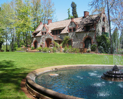
Bourn Cottage
Bourn Cottage

I believe that one of the nuggets of Nevada County is the Empire Mine State Park. Located in Grass Valley, nestled among tall pines, oaks and cedars, it has been brought back to its original grandeur of the mining days of old.

This is really one of the state parks that is a must visit. To mention some of the activities there are 12 miles of beautiful trails for hiking, mountain bike riding and horse back riding. I have ridden my mountain bike on many of the trails and the trails range from flat to very, very steep. Visting the park is like going back in time to the 49’s era, seeing how the miners worked and how the rich mine owners lived.

Hardrock Trail - Photo by Jeff Herman

Tours are available inside the Bourn Cottage, as Volunteers in period dress recreate characters from Empire’s colorful past. This two story country home of William Bourn, Jr., styled after the noble estates of nineteenth century England, was built in the late 1890’s. The architecture is distinguished by a remarkable redwood interior, leaded glass windows and massive granite walls. Cottage Living History tours are available every weekend May through mid-October.

A brief history of the mine:

“For more than a century, from 1850 to 1956, the grumblings and rumblings of the stamp mill could be heard for miles around Grass Valley. Twenty-four hours a day, huge banks of machines sent iron rods crashing into chunks of ore blasted from deep inside the Earth. The noise was a constant. Living near the Empire Mine was like living near an interstate highway: You got used to it, or you went nuts.

“People only noticed when it stopped,” says Donna Jones, interpretive ranger at Empire Mine State Historic Park. “And one of the few times it stopped was when Maude Bourn married. They turned it off for three days.”

Maude Bourn was the daughter of William Bowers Bourn Jr., who took over the mine from his father in 1887 and went on to become a big name in California, leaving, among his many legacies, the 43-room Filoli mansion in Woodside and the Greystone Winery (now headquarters for the Culinary Institute of America) in St. Helena.

Empire Mine was one of the first — and eventually the largest and most productive — hard-rock mining operations in California, having its start with the discovery, in 1850, of flecks of gold in an outcropping of quartz where the park’s main parking lot is now. Some 5.8 million ounces were eventually extracted from the vein.

The usual method of entering the mine was aboard a cable-operated “man skip,” which resembled a giant toboggan on tracks. Twenty men at a time would pile on for the rip-roaring, 600-feet-per-minute ride into the bowels of the Earth.

“They always put the new men in front so that, if they lost their breakfast, it wouldn’t affect anyone else,” Jones says dryly.”

Source Sacramento Bee

For more information of the activities, fees and tour dates visit Empire State Park

If you have visited the park, please leave your comments of your impression of the park.


View Larger Map

Nevada County Community Celebration of Trails to be Held June 6, 2009

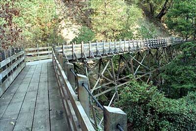
Independence Trail off Hwy 49, Outside Nevada City, Towards Downieville

By: YubaNet.com
And Nevada County Land Trust

Grass Valley, CA May 15, 2009 – On Saturday, June 6 community members will enjoy the second annual Nevada County Celebration of Trails. Events will include a series of hosted trail rides, walks, and other activities throughout the day, between 10:00 am and noon. At 12:30 pm, everyone is invited to a community event held in the parking area of Twin Cities Church in Grass Valley to share trails information and hear exciting announcements of new trails to be dedicated.

Nevada County Land Trust, along with our western Nevada County community partners will sponsor this event to observe National Trails Day. Partners include a number of organizations interested in building, promoting, and maintaining local trail systems including: the City of Nevada City, Gold Country Trails Council, Bicyclists of Nevada County, Friends of Deer Creek, County of Nevada Planning Department, Rattlesnake Neighborhood Association and Sierra Outdoors with John Skinner and Greg Archbald.

National Trails Day is a celebration of trails that evolved from the report of President Ronald Reagan’s President’s Commission on Americans Outdoors. In 1987, the report recommended that all Americans be able to go out their front doors and within fifteen minutes, be on trails that wind through their cities or towns and bring them back without retracing steps. The recommendation, dubbed Trails for All Americans, became the impetus behind several public and private parties joining American Hiking Society in launching National Trails Day in 1993.

Trails activities: 10 am to noon

The public can choose events that suit their interests. Most events are free of charge.

– City of Nevada City and Sierra Club
What: A family friendly hike that will include natural, Maidu, mining, logging and modern history
Where: Hirschman’s Pond Trail – Trailhead located at 115 Cement Hill Rd.
When: 11:00am to 11:30am
Bring: Bug repellent and water. Sorry no strollers

– Nevada County Land Trust and Bicyclists of Nevada County
What: Kenny Ranch Trails, walk, run, mountain bike ride.
Where: Twin Cities Church parking area
When: 10 a.m. to Noon
Bring: Good walking shoes, water and/or your bike

– Friends of Deer Creek and American Rivers
What: National Trails Day Work Day. Volunteer to help work on a local trail.
Where: Champion Mine Rd at Old Downieville Hwy split – take Champion Mine Rd for a couple hundred yards and park in the pull-outs on the right – Trailhead is on the left.
When: 10 a.m. to 11:30 a.m.
Bring: Work clothes and water

– Gold Country Trails Council
What: Poker Ride at Skillman Horse Camp
Where: Tahoe National Forest
When: Sign up begins at 8:30 a.m. Ride out at 10 a.m.
For entry forms visit GCTC online at www.goldcountrytrailscouncil.org or contact Mary Johnson at 530.477.8501.

Celebration of Trails Event: 12:30 pm to 1:30 pm
Join us to celebrate and learn more about trails, hiking activities and outdoor recreation in our community.

– Trails Celebration hosted by Nevada County Land Trust
What: Trails celebration, award ceremony and gathering of outdoor organizations and enthusiasts.
Where: Twin Cities Church parking area, 11726 Rough and Ready Highway, Grass Valley
When: 12:30 to 1:30 p.m.

A full detail of events and activities can be found at Nevada County Land Trust-Trails Event