Tag Archives: Nevada City

Hoof Trimming for Barefoot Performance Horses

httpv://www.youtube.com/watch?v=QMZqB5qiyfU

Note: if you cannot view this video, you need to Click here to download Adobe Flash

Michelle Smith of Nevada City, California, trims three horses in Penn Valley… they are being trimmed for barefoot riding. If you’d like more information about this subject, feel free to contact them at horsedesigns@gmail.com.

Nevada County Airport

httpv://www.youtube.com/watch?v=buYZzj-ORmA
Note: if you cannot view this video, you need Click here to download Adobe Flash

Nevada County Airport is home base to over 140 aircraft with over 30,000 take-offs and landings occurring each year. 

Nevada County Airport was built in 1932 by Errol McBoyle, owner of the Idaho Maryland Mine, to fly gold to Mills Field (now San Francisco International Airport). In 1956, Charles Litton of Litton Industries, gave the airport land to Nevada County as a gift. Later, Nevada County invested over $5 million in upgrading the air park.

Pilot information is at AirVav:KGOO Nevada County Airpark

Nevada County Airport
Manager: Greg Marshall
13083 John Bauer Avenue
Grass Valley, CA 95945
530-273-3374
Fax 274-1003
Email: gregory.marshall@co.nevada.ca.us

By: John J. O’Dell
Real Estate Broker
Call for any of your real estate needs or questions
530-263-1091


View Larger Map

Nevada City Area’s Campaign For Google Fiber Network

As you may or many not know, a lot of cities are vying to have Google invest in bringing high speed internet connection to their city.  We are talking here of having internet connections 100 times faster than most Americans have access to today. Even if you are not interested in high speed internet connection this video gives you the dynamics of this community and how many tech companies there are here. We consider Nevada County as a mini Silicon Valley, with many tech companies that have started and grown up in this area.

This video is Nevada City’s area (95959) to convince Google to bring Google Fiber to their community. It’s very well done.

httpv://www.youtube.com/watch?v=sFhPPAYjdVU

Here’s Google’s Statement as to what they are trying to do:

“Our goal is to experiment with new ways to help make Internet access better and faster for everyone. Here are some specific things that we have in mind:

  • Next generation apps: We want to see what developers and users can do with ultra high-speeds, whether it’s creating new bandwidth-intensive “killer apps” and services, or other uses we can’t yet imagine.
  • New deployment techniques: We’ll test new ways to build fiber networks, and to help inform and support deployments elsewhere, we’ll share key lessons learned with the world.
  • Openness and choice: We’ll operate an “open access” network, giving users the choice of multiple service providers. And consistent with our past advocacy, we’ll manage our network in an open, non-discriminatory and transparent way.”

To read their entire mission go to Experimental Fiber Network

John J. O’Dell
Real Estate Broker

Looking for real estate in Nevada County?
Looking for short sales & foreclosure?

Go to JohnOdellRealty.com

Toastmasters – Helping 235,000 People to Become Stronger Leaders

By Lisa J. Lehr

Would you like to have more communicative employees—or be one? Have a more effective sales force, or be a trainer with phenomenal presentation skills? Be a more confident, competent leader? Be persuasive, inspirational, and/or entertaining?

That’s what 235,000 people around the world are doing right now, and it’s called Toastmasters International.

This might sound like a shameless plug for Toastmasters…and perhaps it is, because I’ve been a member of Toastmasters for over 10 months now, and I love it, and so do my fellow Toastmasters, and we’d love to have more company!

Toastmasters is an international organization that provides training in speaking and leadership that is on a par with expensive and extensive professional training programs, yet at a fraction of the cost and time commitment.

Nevada County is lucky to have four different Toastmasters Clubs—unusual for a community of our size. Mother Lode Toastmasters meets Monday evenings; Early Risers Toastmasters, Tuesday mornings; Penn Valley Club, Wednesday evenings; and the club I belong to, Empire Toastmasters, meets every Friday at noon at Trolley Junction Restaurant (at the Northern Queen Hotel) in Nevada City.

We’re a small, friendly, supportive group dedicated to helping each other improve at a comfortable pace, wherever we each currently are with our speaking and leadership skills. Our meetings are open to anyone who is interested. Come as a guest; you’ll be invited (but not required!) to participate in Table Topics, in which participants each speak impromptu for about a minute on a given theme. It’s often the highlight of the meeting, and almost always provides the most laughs. Lunch is $14 and reservations are not required.

My fellow Toastmasters and I are available to do a presentation for your business or organization that will explain the program in much greater detail. My own personal and professional growth through Toastmasters has been nothing short of astonishing in less than a year, and my fellow club members have similar stories to tell about being “the shyest person who ever lived”—but no more, thanks to Toastmasters!

Visit this link for more information about the local clubs:

ToastMasters Nevada County

Lisa J. Lehr is a writer and copywriter living in Grass Valley. She can help you promote your business with a full range of online and offline marketing pieces. A member of Empire Toastmasters, she’s available to speak to your business or professional group. Visit her website www.justrightcopy.com for more information, opt in for a message series, and receive a free Marketing Guide.

Lisa J. Lehr
I write words that make you money–just ask me how.
Visit my website and sign up for my fr~ee marketing tips.
New! No~cost Marketing Guide now available at my website.

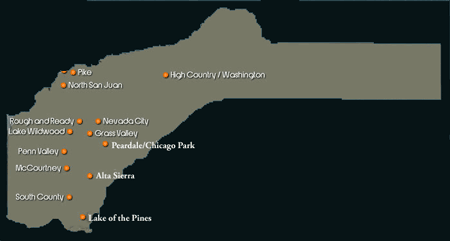
Residential Sales in Nevada County November 2009 Compared to November 2008

 map-of-nevada-county

The good news is that sales volume picked up 7 percent.   In November of 2007 to November of 2008, 839 homes had been sold.  From November 2008 to November 2009 897 homes were sold, an increase of 7 percent.

The average sales price in November 2008 was $395,609. In November 2009 the average sales price was $316,859.  This is a decrease of $78,650 or a 20 percent drop in average sales price.  The amount of active listings also dropped 7 percent.

Sales bya few key areas:

 Nevada City area sales increased 17 percent and average sales price dropped 22 percent. The average sales price in November 2009 was $364,800 compared to a year ago of $468,895.

Lake Wildwood sales increased 11 percent and the average sales price dropped 14 percent to an average sales price of $316,216 compared to last year’s average sales price of $368,366.

Lake of the Pines sales decreased 3 percent and the average sales price dropped 20 percent to an average sales price of $313,188 compared to $368,366 last year.

Alta Sierra sales increased 20 percent and the average sales price dropped 26 percent to an average sales price of $305,537 compared to last year’s average sales price of $410,415.

Grass Valley’s sales decreased 3 percent and the average sales price dropped 16 percent to an average sales price of $267,024 compared to last year’s average sales price of $318,072.

Penn Valley sales decreased 10 percent and the average sales price dropped 12 percent to an average sales price of $319,370 compared to last year’s average sales price of $361,450.

Peardale/Chicago Park sales decreased 2 percent and the average sales price decreased 20 percent with an average sales price of $382,940 compared to last year’s average sales price of $476,855.

There are other areas of the county which I have not mentioned. If you are interested in any particular area that is not in the list above, write or call me and I will give you the stats.

John O’Dell
Broker

Realty World, O’Dell Realty Group is Now John O’Dell Realty

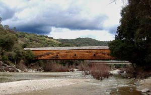
Bridgeport Covered Bridge, Nevada County, CA


I’m pleased to announce that we are no longer a part of the Realty World, Northern California franchise.  No longer being part of the corporate world, we are back to being your home town real estate company, locally owned and operated. We are also using our original name, O’Dell Realty. Please go to our website John ODell Realty   There you can search for all the  MLS listings, foreclosures or put yourself on a free mailing list of homes with your own criteria to find exactly the home or land that you are looking for.

With the advent of the world wide web, there is no need for being a part of a corporate franchise. Along with our own web site, we can provide you with large exposure on many other websites, such as Realtor.com, Trulia and others, to mention just a few. Of course your property is also listed  on the Nevada County Multiple Listing service.  We also have direct access to all of the Bay Area  MLS’s and beyond, along with most of the Northern California MLS’s. Currently we are working with clients buying property in the Bay Area, along with our clients here in Nevada County.

We want to thank our clients that has helped us to be successful for these many years.

Thinking of buying or selling?
For all your real estate needs
Email or call:

John J. O’Dell Realtor® GRI
Civil Engineer
General Contractor
(530) 263-1091
Email jodell@nevadacounty.com

Enhanced by Zemanta

South Yuba River Independence Trail in Nevada County

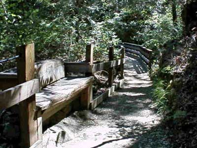
independence-trail-bench-tr

One of the many nice trails located in Nevada County is the South Yuba River Independence Trail. I have walked this trail many times and it is truly a unique natural and historic jewel. The trail is fairly level, with wheelchair accessibility on both on the west and the east trail.

The main entrance to the Trail is on Highway 49, 5.5 miles from Nevada City, heading towards Downieville, near the South Yuba River bridge. Parking is available beside the road, with several marked disabled spaces. Highlighting the West Trail is a waterfall one mile from the entrance. People and wheelchairs travel a switchback ramp from Flume 28 (520 feet long) to the swirling waters of Rush Creek. Also featured on the west side is an overlook of the Yuba River, surrounded by canyon flora. The East Trail features cliff-hanging flumes, more views of the river and foothill landscapes, with a total of two and a half miles of maintained trail. There are picnic areas, outhouses, and scenic vistas all around. The Independence Trail is for all people, with its gradual, level walkway – from young mothers with stroller kids, to serious hikers and joggers, to seniors with limited mobility, to those in wheelchairs. Bathrooms are available along the way.

The origin of the Independence Trail was an old, abandoned miner’s ditch, previously known as the Excelsior Canal. It was built to carry water from the South Yuba river to hydraulic mining sites in Smartsville, 25 miles downstream. When California outlawed hydraulic mining in 1884, the ditch was used for irrigation until 1967, when it was abandoned. In 1975, a docent of the Oakland Museum, John Olmsted, re-discovered the whole water system consisting of the ditch, the berm, where the ditch-tender walked, and the wooden flumes which bridged the ravines. He had the vision to recognize that this could be the answer to a friend’s lifelong dream: “Please find me a level wilderness trail where I can reach out and touch the wildflowers from my wheel chair.”

Hiking distance: 2.5 miles downstream (west) or upstream (east) The west trail offers a 4.3 mile loop along a swimming trail to Jones Bar Road and then goes back to Excelsior Canal and back to the start.
To start Go 5.5 miles from Nevada City towards Downieville just short of the South Yuba River. There is parking along Hwy 49 including handicapped spaces.

Caution:
Winter and Spring weather conditions can cause the trail to become muddy and impassable for wheelchairs.

Call the South Yuba River State Park for trail condition information before you go.

More Information South Yuba Indendence Trail


View Larger Map