You’ve got lots of stuff, and the garage is a super-convenient place to put it. But putting these items out there could be hazardous—for them, or for you
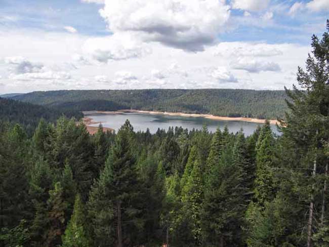
The water level in the lake is down further than I’ve seen since I’ve lived in Cascade Shores, or at least it seems that way. Scotts Flat Lake or should I say reservoir, what’s the difference? A lake is a body of water but a reservoir is different because it’s level is deepest at the dam and some other technicalities . Oh, well, I still like to call it a lake. If you really want to know the difference between a lake and reservoir go to Lakes & Reservoirs.
If you want to see the projected water level for Scotts Flat Reservoir that was prepared by Nevada Irrigation District, go to picture 5. I’m guessing from my pictures and the graph for water levels for Scotts Flat Lake that the present elevation is around 3,036 foot elevation. The high appears to be 3,062 feet in elevation. That’s a 26 foot drop which cuts the water storage in half, from 40,000 acre feet to 25,000 acre feet. An acre foot is one foot of water over one acre of land or 43,560 cubic feet of water.
Scott’s Flat is situated among the tall pines at the 3100-foot elevation nine miles east of Nevada City via Highway 20 and Scott’s Flat Road. It offers 169 campsites at two large campgrounds, plus a group camp. Across the lake, accessible via Red Dog and Quaker Hill Roads from Nevada City, is the Cascade Shores Day Use Area. As you can see from my pictures, there a lot of trees around the reservoirs, oops lake.
Please help to keep this blog going
Let us Sell or help you buy your new home or land
John J. O’Dell Realtor® GRI
O’Dell Realty
(530) 263-1091 Email John
Rinò Minetti of Milan, Italy and Photographer John Daly of Nevada City, CA. They met online and have worked together to create these images from their work, Daly’s Photography and Rinò’s Digital Art. Sometimes a final image is made of one image from each, combined into a new image. Sometimes there will be multiple images from each, combined into one new image. This collaboration has been very creative and great fun for us.
We hope you enjoy our work.
John Daly & Rinò Minetti
Please help to keep this blog going
Let us Sell or help you buy your new home or land
John J. O’Dell Realtor® GRI
O’Dell Realty
(530) 263-1091 Email John
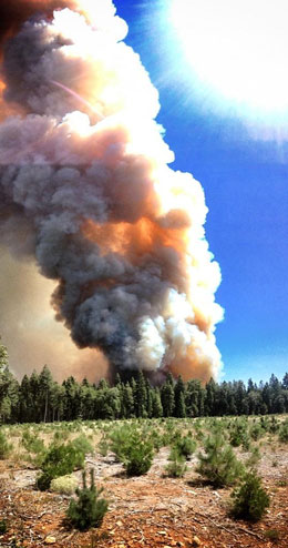
We continue to have smoke here in Nevada County. The American Fire is now 81% contained but it has burned over 24,400 acres.
Fire Status: The south, west and north perimeters of the fire remainin patrol status. This is due to completion of fire lines and minimalto no hot spots being detected inside the fire line in these areas.Crews have completed burning operations adjacent to the Mosquito Ridge Road, along the eastern perimeter. These burning operations haveconsisted of fire fighters lighting low intensity (“cool”) fire withthe intent of reducing ground fuels between the fire perimeter and themain fire. This tactic was highly successful as it reduced thepotential of the main fire escaping containment lines. Now thatburning operations are completed, these same crews will transitioninto detecting and extinguishing any remaining hot spots.With increased containment of the fire, additional fire crews havebegun work repairing areas affected by fire fighting activities. This has included chipping material piled next to roads during fire line construction as well as identifying needs to construct water controldevices along fire lines throughout the fire area.Forest visitors are asked to adhere to area and road closures. Theseclosures are in place to protect visitors and fire fighters. The roads and areas that have been closed are unsafe due to fire-weakened,burned trees that pose a risk of falling, as well as frequently heavy smoke making visibility extremely poor. These areas and roads will be re-opened as soon as possible.
Hand Crews: 28 Engines: 79 Dozers: 13 Water Tenders: 35 Helicopters: 4
Closure Update: Mosquito Ridge Rd (FSR 96) remains closed from thejunction of Ralston Ridge Rd (FSR 96-023) to the junction of theDuncan Diversion Dam access road (FSR 96-052), west of French Meadows Reservoir. Foresthill Rd remains closed from Humbug Canyon Road (FSR88-066) to Robinson Flat Campground and Forest Rd 43 (Robinson FlatRd) remains closed from Robinson Flat Campground to Mosquito Ridge Rd.Robinson Flat Campground and Duncan Peak Lookout also remain closed. French Meadow Reservoir and access to the Oxbow Middle Fork American Rafting Launch put in remain open.
A Community Meeting will be held tonight, Monday, August 26 at 7 p.m.at the Foresthill Veterans Memorial Hall, 24601 Harrison Street,Foresthill.Forest Order No 17-13-06 has closed portions of the Tahoe NF on theAmerican Ranger District.http://tinyurl.com/mvx4w3c
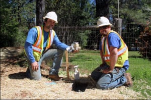
NID employees Chad Garvey, left, and Andrew Browning prepare to install a new water meter along Rattlesnake Road near Grass Valley
GRASS VALLEY – Treated water is now available in the Rattlesnake Road-Wheeler Cross Road area near Grass Valley, following a water line extension project completed this month by the Nevada Irrigation District.
NID and area property owners shared costs in extending a 16-inch main line from Dog Bar Road, across Wheeler Cross Road to the Rattlesnake Road intersection and 1000 feet north on Rattlesnake Road.
The job, with about 3000 feet of new pipe and three new fire hydrants, was completed for NID by C&D Contractors, Inc. of Nevada City. New pavement overlay has been added throughout the project area.
Chip Close, NID’s interim water operations manager, said the project progressed rapidly through planning, design and construction after contracts were signed with participating property owners. ”Our new customers were receiving water within nine months,” he said. ”Our contractor was able to take advantage of the dry weather and good working conditions this winter.”
Officials said the new pipeline is part of the district’s master plan and can eventually be extended across Rattlesnake Road to existing pipelines near Highway 174, depending on public demand.
District maintenance crews are now installing new water meters at the 13 parcels that participated in the water line extension project.
Area residents with questions about NID water public water supplies may contact NID Business Coordinator Shannon Matteoni at (530) 273-618
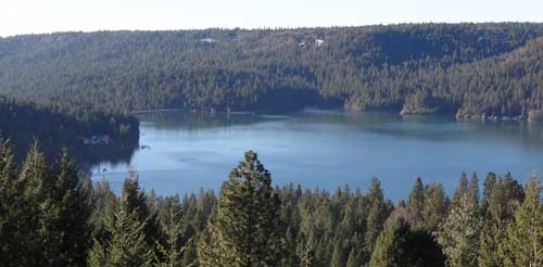
Scotts Flat Reservoir seems to be very close to the spillway elevation which is approximately 3074.8 feet in elevation. That’s the elevation in which the water starts flowing out due to increase in volume from rainfall or from release of water from upper dams. As of today, the elevation of the water is 3073 or about 1.8 feet from flowing over the spillway.
In the pictures above, you can see how close to the top of the dam the water is. Camping, fishing, swimming, sunning, boating, water skiing, sailing, board sailing and other activities are popular at Scotts Flat reservoirs in the Sierra foothills. Day use parks, campgrounds and beaches which is operated by a private operator under contract with Nevada Irrigation District.
Scotts Flat is situated among the tall pines at the 3100-foot elevation nine miles east of Nevada City via Highway 20 and Scotts Flat Road. It offers 169 campsites at two large campgrounds, plus a group camp. Across the lake, accessible via Red Dog and Quaker Hill Roads from Nevada City, is the Cascade Shores Day Use Area.
For all your real estate needs
Email or call today:
John J. O’Dell Realtor® GRI
Civil Engineer
General Contractor
(530) 263-1091
Email jodell@nevadacounty.com
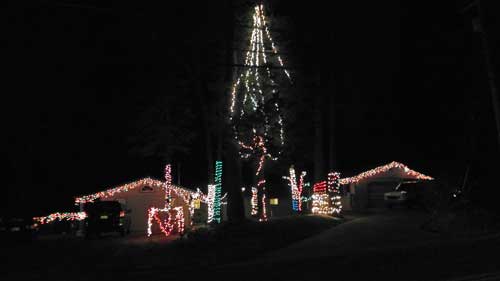
Here’s some more Christmas scenes off of Banner Quaker Hill Road near Nevada City. Do you have pictures of your Christmas lights that you would like published? Please send them to me and I’ll gladly post them.
Happy Holidays to all.
For all your real estate needs
Email or call today:
John J. O’Dell Realtor® GRI
Civil Engineer
General Contractor
(530) 263-1091
Email jodell@nevadacounty.com
This house so nicely decorated is located in Cascade Shores on Banner Quaker Hill Road. It’s a little hard to take good pictures because of the many pine trees in the way. Shots were taken with Samsung WB850F camera with F2.8 at 1/10 second. Camera has GPS tagging which is great when you are traveling since you can always go back to see where you took the picture.
Merry Christmas to all.
For all your real estate neeeds
Call or email:
John J. O’Dell Realtor® GRI
Civil Engineer
General Contractor
(530) 263-1091
Email jodell@nevadacounty.com
The earliest settlement in Nevada County was made in the summer of 1848 at a place called Rose’s Corral which was located between the Anthony House and Bridgeport. Early in the spring of 1849 a group of mountaineers from Oregon known as the Greenwood Company mined for gold at Illinois Bar on the South Yuba River. They were followed by emigrants from Indiana. In the fall of 1849, the Greenwood Company made winter camp at Jefferson, and the Indiana group moved further upstream to Washington. In that same autumn that Captain John Pennington’s party struck rich diggings on Deer Creek and built the first cabin on Gold Run, the site that was to become Nevada City.
Originally a mining camp founded along Deer Creek in 1849, Nevada City rapidly became the largest and wealthiest mining town in California. At one point, Nevada City was the third largest city in California with a population of 10,000. Nevada City’s good fortune allowed miners and settlers to enjoy plush gambling establishments, hotels, saloons, and stores. However, like many big cities that sprang up quickly during the rush for instant wealth, early Nevada City shared a darker side of claim jumping, murder, brothels and opium dens.
By the 1850’s Nevada City’s wealth began to wane, and as miners moved on in search of new claims and stories of gold and riches, a quiet and quaint city emerged. Two fires in 1856 and 1863 raced through Nevada City almost completely wiping out the town. The beautiful architecture that stands today is testament to the will of the people of Nevada City who rebuilt the town completely not once, but twice.
Hydraulic mining, Nevada County, CA, 1866 Photo courtesy of http://www.lawyersgunsmoneyblog.com
Nevada County was created in 1851 from parts of Yuba County because of the increase in population in the area and the distance to travel to courts which made it necessary to create a new county. The county was named after the mining town of Nevada City, a name derived from the term “Sierra Nevada.” The word nevada in Spanish means “snowy” or “snow-covered.” Nevada City has carried many monikers through its history; Caldwell’s Upper Store, Coyoteville, and Deer Creek Dry Diggings, but Nevada was chosen in the 1850s to give the town a cultured name.
Nevada City, CA, USA (Photo credit: Wikipedia)
In 1851 the newly formed Nevada County copied the name. The State of Nevada used the name 10 years later in 1861. The region came to life in the gold rush of 1849. Many historical sites remain to mark the birth of this important region in California’s formative years. Among them are the Nevada Theater in Nevada City, which operates to this day and once hosted Mark Twain among other historical figures. The gold industry in Nevada County thrived into the post WWII days.
The county had many firsts and historic technological moments. The first long-distance telephone in the world, built in 1877 by the Ridge Telephone Company, connected French Corral with French Lake, 58 miles (93 km) away. It was operated by the Milton Mining Company from a building on this site that had been erected about 1853. The Pelton wheel, designed to power gold mines, still drives hydro-electric generators today. Nevada City and Grass Valley were among the first California towns with electric lights.
Commemorating World’s First Long-Distance Telephone Line. Monument located in French Corral, California. Picture courtesy of http://www.noehill.com
The Olympics, NASA, and virtually every television station around the country utilizes video/broadcasting equipment designed and manufactured by Grass Valley Group, founded in Grass Valley. Electronic medical dosing equipment was first developed and manufactured in Nevada County. The first commercially viable picture-phone was developed in Nevada City. More than fifty high tech and applied tech companies, and more than one thousand hardware and software design and development professionals.
Judy J. Pinegar is a writer and her articles have appeared in many publications.
For all your real estate needs
Email or call today:
John J. O’Dell Realtor® GRI
Civil Engineer
General Contractor
(530) 263-1091
Email jodell@nevadacounty.com
Photo courtesy of Washington Hotel www.washingtonhotel.net
By Judy J. Pinegar
This little town in Nevada County is located on the banks of the South Fork of the Yuba River. It is located off Highway 20 between Nevada City and Interstate 80. Washington boasts a population on about 200, but that fluctuates seasonally and the town has a lot of tourist traffic in the summer.
Washington was founded in 1849, as were most of the cities in Nevada County; it was all about the Gold Rush!! These particular miners were from Indiana, so the settlement was first named Indiana Camp, but renamed to Washington in 1850. The area produced a large amount of placer gold, after that hard rock and hydraulic mines were established and were also very productive. Many people of Chinese descent worked in the area at these times.
The hotel in the town of Washington started with Hessel B. Buisman who was born in Holland in 1827, he landed in San Francisco in 1850. He originally kept a hotel in the town of Jefferson located near Washington from 1852 to 1857. He then came to Washington building a two story hotel which could accommodate up to 30 guests.
After the Buisman owners passed away, their daughter and her husband Eldridge Worthley kept the hotel for years. The hotel was called “The Worthley” or “Washington Hotel” and sat on the same site as the current hotel today. The hotel stable was across the street.
At 11 PM, August 16th, 1867 The Big Fire broke out in a nearby cabin. It jumped from house to house and destroyed almost every business downtown Washington including the Hotel. The hotel was rebuilt.
On April 21st, 1896 another fire started in the kitchen of the Washington Hotel. This fire destroyed the hotel and several buildings nearby. This time, Worthley had taken out fire insurance previous to the fire. The hotel was rebuilt as fast as the weather would allow. The picture shows the new and improved Washington Hotel after being rebuilt in 1896.
Photo courtesy of Washington Hotel www.washingtonhotel.net
The Washington Mining District was always served by operators of small stage lines. This photo shows the company stage of Prescott and Grissel. A daily trip used to leave The National Hotel in Nevada City at 7 AM and arrive in Washington around noon. This was used to rest between trips or take shelter from the weather. Now the drive only takes 25 minutes in your car.
Picture from the Red Ledge Mine in Washington. The gold/quartz veins occur in the sedimentary rocks close to the contact with serpentine. Mariposite is often in association with the serpentine, and in close proximity to the gold. Photo courtesy of http://www.mindat.org/loc-3515.html
The town of Washington currently consists of the Washington Hotel/bar, a restaurant, a grocery store, a one room schoolhouse that has educated students continuously for over 100 years, and two trailer park campgrounds
There are two trailer parks, Gene’s Pine Aire Campground and the River Rest Resort have been in business since the 1960’s with various owners. Campsites are often to capacity, so reservations are advised.