Tag Archives: Tahoe National Forest

Tahoe National Forest Prescribed Burns Planned in Nevada, Sierra, and Yuba Counties

Tahoe control burn

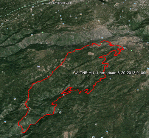
This fall the Tahoe National Forest plans to accomplish approximately 1,200 acres of pile burning and 300 acres of underburning on the Yuba River Ranger District within Nevada, Sierra, and Yuba counties. Prescribed burn operations will begin this week and will extend through the fall, depending on current and predicted weather.

The planned pile burns are located in approximately 40 administrative sites across the district. Sites likely to be most visible include those along Highway 49 adjacent to Goodyears Bar; near Forest City; along Canon Point Road west of Downieville; west of Alleghany; in the Pendola Fire area; near Cascade Shores; and along Highway 20 east of Nevada City. Underburning will occur along Highway 20 east of White Cloud and north of Camptonville.

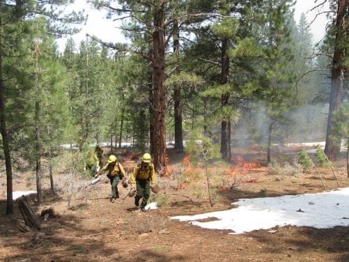
The prescribed burns will reduce the understory vegetation to enhance the chance of forest survival from high-intensity wildfire; improve wildlife habitat and forage; and re-create the ecological benefits from low-intensity fire.

The Forest Service will only initiate the burns with favorable weather conditions, including humidity, temperature, and wind speed and direction. Moisture levels within the vegetation itself are also considered. Forest Service fire managers work diligently with air quality management districts to minimize smoke impacts to the communities.

For questions regarding these prescribed fires, please call District Fire Management Officer Mike Cherry at (530) 478-6253.

For more Tahoe National Forest information, go to http://www.fs.usda.gov/main/tahoe/home.

Read an interview with a TNF Fire Cheif, Jeanne Pincha-Tulley on why the Forest Service uses Prescribed Burning.

Enhanced by Zemanta

Please help to keep this blog going
Let us Sell or help you buy your new home or land

John J. O’Dell Realtor® GRI
O’Dell Realty
(530) 263-1091
Email John

BRE#00669941

American Fire Video

httpv://youtu.be/YhuL9QWkfX8

The American River Fire continues to burn. Heavy smoke continues in the recent areas that I traveled, Nevada City, Grass Valley, Auburn and Roseville. As of this morning, 14,822 acres have been consumed by fire.

The fire is approximately 10 air miles northeast of Foresthill, CA, in steep, rugged terrain. While the fire is predominantly burning on the Tahoe National Forest within the North Fork of the Middle Fork American River drainage, there is a potential, given changes in weather or fire behavior, for the fire to threaten areas near Foresthill.

Active fire behavior continues on the eastern and southern flanks of the fire. Overnight, crews continued to build hand and dozer line to contain the active fire while evaluating future containment options. Firefighters will mop up and patrol containment line along Deadwood Road and Foresthill Divide Road south to the dozer line. Indirect line construction and mop up will continue down Deadwood Ridge. On the east side near Antoine, Manila and Screwauger Canyons, direct and indirect line construction will continue, with support of retardant drops.

Active fire behavior and roll out of burning material continue to be of concern, and will be closely monitored. Strong, erratic outflow winds and lightning may occur today, as the National Weather Service’s Red Flag Warning remains in effect until 11 p.m. Wednesday.

Active fire behavior in very steep, inaccessible terrain makes preparation of contingency lines critical. Indirect attack is the safest way to manage fire in areas of steep and difficult terrain.

American Fire perimeter August 20, 2013

Please help to keep this blog going
Let us Sell or help you buy your new home or land

John J. O’Dell Realtor® GRI
O’Dell Realty
(530) 263-1091
Email John

DRE#00669941

Enhanced by Zemanta

Heavy Smoke Over Scott’s Flat Lake

Smoke over Scotts Flat Lake August 12, 2013. Picture taken by John O'Dell from my deck.
Smoke over Scott’s Flat Lake August 12, 2013. Picture taken by John O’Dell from my deck.

I woke up this morning and looked out my window to discover that Scotts Flat Lake was covered with smoke. Wondering where the fire was and hopefully not near my house, I looked at the Cal-Fire website to determine the location of the fire. Since the fire is in the Tahoe National Forest, I linked from Cal-Fire’s website  to  InciWeb for farther information

The fire started last Saturday around 4:10 pm.  Judy and I were at a wedding in Forest Hill at that time and we noticed smoke in and around Forest Hill.

The American fire is burning in a heavily forested area of very steep terrain on Deadwood Ridge, approximately 17 miles northeast of Forest Hill in Tahoe National Forest. Access to the fire is limited, and firefighter safety is a concern due to difficult terrain.

Fire size is estimated at 800-1,000 acres, with heavy smoke making it difficult to obtain precise numbers. The fire has crossed the North Fork of the Middle Fork of the American River and is burning toward the Last Chance area. Firefighters reported a moderate rate of spread with short uphill runs yesterday, and more of the same is expected today. Firefighters were able to make some progress on line construction overnight.

Multiple Forest Service and Cal Fire engines, crews, dozers, air tankers, and helicopters are committed, with additional resources on order. Smokejumpers are being utilized. Efforts are being focused mainly on the Deadwood Ridge and Last Chance sides of the fire. While firefighters are working to protect cultural resources from the fire and from suppression impacts, firefighter and public safety are the first priorities.

The Central Coast #7 Type II Incident Management Team is en route and expected to arrive today.

Smoke in the areas of Foresthill, Auburn, Nevada City, and the valley will likely continue over the next several days.

There are no current road closures, but people are being asked to stay out of the fire area for their own safety and the safety of firefighting personnel.

The town of Foresthill is not endangered and there are no evacuations ordered.

Fire Location


View Larger Map

Please help to keep this blog going
Let us Sell or help you buy your new home or land

John J. O’Dell Realtor® GRI
O’Dell Realty
(530) 263-1091
Email John

DRE#00669941

Enhanced by Zemanta

Burn Permits Suspended June 1st Tahoe National Forest Initiates Fire Restrictions

Photo Credit: maderafsc.org

Effective Saturday, June 1, 2013, residential burn permits will be suspended for Nevada, Placer, and Yuba Counties and fire restrictions will go into effect in the Tahoe National Forest announced both Brad Harris, CAL FIRE Nevada-Yuba-Placer Unit Chief and Tom Quinn, Tahoe National Forest Supervisor.  “Despite the recent, light rain, conditions in the foothills and the high country remain unseasonably dry for this time of year.  Warming temperatures, dry winds, and very dry fuel moisture levels have prompted this early fire season response,” stated Quinn.    “We have already seen fire activity that is not normally observed until late July or August.  The unusual lack of rain this past winter and spring, prompted the early burn ban and fire restrictions,” said Chief Harris.

Beginning June 1, the burn permit suspension applies to areas in Nevada, Yuba and Placer counties that fall within state responsibility area and local jurisdiction under contract with CAL FIRE.  Anyone who burns in violation of the suspension will be subject to appropriate civil or criminal action and could face cost recovery charges for the fire suppression response.  All fires or smoke reported will be considered a wildfire and a full suppression response will be dispatched to the scene.

In the Tahoe National Forest, beginning June 1, campfires are not permitted in the backcountry but only in developed campgrounds and other designated sites (in the metal rings/grills provided).  Portable stoves, including those that use gas, jellied petroleum or pressurized liquid fuel are permitted in backcountry areas with a valid campfire permit.  Propane-type Bar-B-Q’s can be used outside designated sites where camping is permitted, but charcoal Bar-B-Q’s can only be used in designated campgrounds.  Smoking is only permitted in an enclosed vehicle or developed recreation site.  Internal combustion engines, including off highway vehicles (OHV’s) can continue to be operated on roads or motorized trails and within the Prosser Pits OHV area.  The personal wood cutting program will continue to operate, as long as individuals have a valid woodcutting permit and follow the conditions on the permit. Campfire permits are free and are available at all Forest Service, BLM, or CAL FIRE offices.

Continue reading Burn Permits Suspended June 1st Tahoe National Forest Initiates Fire Restrictions