Category Archives: Lakes in nevada county

NID Adopts Drought Plan; Calls for 20% Conservation

Looking over Scott's Flat Reservoir Picture taken from my deck John J. O'Dell
Looking over Scott’s Flat Reservoir Picture taken from my deck John J. O’Dell

March 25, 2015

Directors of the Nevada Irrigation District on Wednesday (Mar. 25) adopted a series of drought measures that include limits on outdoor watering and a call for continued 20 percent reductions in water use by all district customers.

In a presentation to the NID Board of Directors, Water Operations Manager Chip Close recommended a package of conservation measures designed to meet requirements adopted Mar. 17 by the State Water Board and to ensure that NID has adequate carryover water storage going into next year in case the drought continues into a fifth year.

Urban Water Use

Drought measures in effect for users of piped, treated water include:

  • Outdoor watering no more than three days per week, with no watering during the heat of the day (10 a.m. to 6 p.m.).
  • No watering until 48 hours after a rain.
  • No drinking water service in restaurants unless requested.
  • Hotel and motel guest option of not having towels and linens changed daily.
  • No water use that creates unnecessary runoff.
  • Use of shutoff nozzle on hoses.
  • No washing down of sidewalks
  • Fountains must recycle water

NID and other water purveyors are being required to provide the State Water Board with monthly reports on water use, conservation compliance and enforcement efforts.

Irrigation Water Use

Drought measures in effect for users of canal water include:

  • Voluntary reductions of 20 percent or more with mandatory reductions possible later in the year if conservation goals are not being met.
  • New and increased irrigation water sales are limited to the smallest amount of water necessary for the customer’s beneficial use.
  • All customers are encouraged to use efficient irrigation practices.
  • The irrigation season, which normally runs Apr. 15-Oct. 14, could be shortened this year depending on water availability.

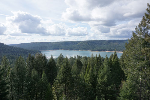
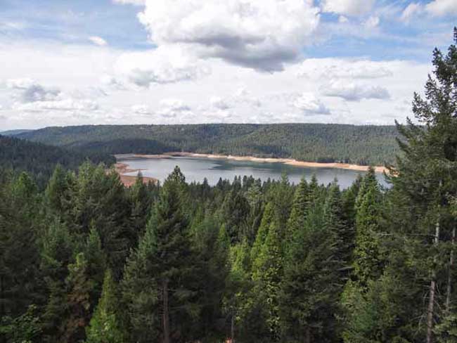
In a water supply update, Water Resources Superintendent Sue Sindt said this year’s water outlook is slightly worse than last year.  She said the mountain snowpack is only about 6 percent of average water content for this time of year and that seasonal runoff is anticipated to be only 20-25 percent of average.

Officials credited district customers with reducing water use by an overall 16.4 percent during the 2014 drought and said an equal level or more will be needed to get through this year.

Close said that continued conservation, tight measurement and controls on the canal system, and the purchase of an available 20,000-25,000 acre-feet of additional water from the Pacific Gas and Electric Company will help meet the district’s water supply needs for this year and next.

For drought information and helpful water efficiency advice, please see NID’s website atwww.nidwater.com.  Water waste may be reported through an online form or by telephone, (530) 271-6799.


Help keep this blog going
Call or write today for all your
real estate needs

John J. O’Dell Realtor® GRI
O’Dell Realty
(530) 263-1091
EMail John O’Dell
BRE#00669941

Error: Contact form not found.

Nevada Irrigation Districts Lakes and Canals have Unusal Titles

Scotts  Flat Reservoir. Picture taken from my deck. John J. O'Dell
Scotts Flat Reservoir. Picture taken from my deck. John J. O’Dell

How’s the water out there in Wiskey Diggins Canal? Was the Fiddler Green Canal titled after an early day musician? Did you ever wonder how the DSL Canal was named?

The names of water storage and distribution facilities throughout NID are colorful and unusual but, unfortunately, the origination of many of them has been lost through the years.

Many facilities are named for builders, such as Faucherie Reservoir, or for the geographic areas they serve, such as Bald Hill or Pet Hill canals.

Of course, many lakes and canals carry names that are rooted in the area’s rich mining history.

The DS Canal is the lowest elevation of the two NID canals crossed by Red Dog and Banner Lava Cap roads near Nevada City. It was built by NID in 1927-28 to carry water from Lower Scotts Flat into the Nevada City-Grass Valley area.  The DS Canal follows the south side of Deer Creek, hence DS for Deer Creek South. If NID had followed through with an initial plan for a canal on the north side, we would today have the DN Canal.

How Scott Flat was named is unclear, but it is widely understood that it was due to the Scottish miners who lived and worked there in the 1850’s and 1860’s.  Schools once stood near what is now the campground on the north side of the lake.

Rollins Reservoir was named for J.L. Rollins, manager of the Bear River Water and Power Co., the company from which NID acquired the land to build the reservoir.

NID’s first modern water treatment plan, the Elizabeth L. George plant on Banner Mountain, opened in 1969 and was named after the long time community leader who helped gain funding for its construction.

In the high country, Faucherie Reservoir, built prior to 1880, was named after a French engineer who worked for the Eureka Lake & Yuba Canal Co.  “The French must have had a strong influence because French Lake, located upstream of Faucherie and constructed in 1857-59 was originally called Eureka Lake and later changed to French Lake,” wrote NID retiree Terry Mayfield who documented much of the district’ history during his 34 years with the district.

One of NID’s most historic canals is reputed to be the first mining canal in the state.  The Rough & Ready Canal was begun in 1850 as the first effort to build a large-scale mining ditch in California.

According to the Thompson & West History of Nevada County, “a man named Moore commenced to dig one from Deer Creek above Nevada City to Rough and Ready. The magnitude of the undertaking astounded the miners and they thought Moore was a lunatic, but he persevered until he had completed one mile, and then abandoned the enterprise.”

Moore’s project was taken over by a company in 1851 and by 1854 the canal to Rough & Ready was complete. NID took over the canal in 1925 as part of a water system acquired from the old Excelsior Water & Power Co.  Portions of the 13-mile-long Rough and Ready & Ready Canal remain in use today.

Source: Nevada Irrigation District newsletter Volume 35 Number 4 Winter 2014/2015

Help keep this blog going
Call or write today for all your
real estate needs

John J. O’Dell Realtor® GRI
O’Dell Realty
(530) 263-1091

Error: Contact form not found.


BRE#00669941

Scotts Flat Reservoir Lake Level September 2014

Scotts Flat Reservoir

Scotts Flat Reservoir
Picture 1 of 9

Scotts Flat Reservoir


Pictures  by John J. O’Dell from my deck.

The water level in the lake is down further than I’ve seen since I’ve lived in Cascade Shores, or at least it seems that way.  Scotts Flat Lake or should I say reservoir, what’s the difference?  A lake is a body of water but a  reservoir is different because it’s level is deepest at the dam and some other technicalities . Oh, well, I still like to call it a lake.  If you really want to know the difference between a lake and reservoir go to Lakes & Reservoirs.

If you want to see the projected water level for Scotts Flat Reservoir  that was prepared by Nevada Irrigation District, go to picture 5.  I’m guessing from my pictures and the graph for water levels for Scotts Flat Lake that the present elevation is around 3,036 foot elevation. The high appears to be 3,062  feet in elevation.  That’s a 26 foot drop which cuts the water storage in half, from 40,000 acre feet to 25,000 acre feet. An acre foot is one foot of water over one acre of land or 43,560 cubic feet of water.

Scott’s Flat is situated among the tall pines at the 3100-foot elevation nine miles east of Nevada City via Highway 20 and Scott’s Flat Road. It offers 169 campsites at two large campgrounds, plus a group camp. Across the lake, accessible via Red Dog and Quaker Hill Roads from Nevada City, is the Cascade Shores Day Use Area. As you can see from my pictures, there a lot of trees around the reservoirs, oops lake.

Please help to keep this blog going
Let us Sell or help you buy your new home or land

John J. O’Dell Realtor® GRI
O’Dell Realty
(530) 263-1091
Email John

BRE#00669941

Heavy Smoke Over Scott’s Flat Lake

Smoke over Scotts Flat Lake August 12, 2013. Picture taken by John O'Dell from my deck.
Smoke over Scott’s Flat Lake August 12, 2013. Picture taken by John O’Dell from my deck.

I woke up this morning and looked out my window to discover that Scotts Flat Lake was covered with smoke. Wondering where the fire was and hopefully not near my house, I looked at the Cal-Fire website to determine the location of the fire. Since the fire is in the Tahoe National Forest, I linked from Cal-Fire’s website  to  InciWeb for farther information

The fire started last Saturday around 4:10 pm.  Judy and I were at a wedding in Forest Hill at that time and we noticed smoke in and around Forest Hill.

The American fire is burning in a heavily forested area of very steep terrain on Deadwood Ridge, approximately 17 miles northeast of Forest Hill in Tahoe National Forest. Access to the fire is limited, and firefighter safety is a concern due to difficult terrain.

Fire size is estimated at 800-1,000 acres, with heavy smoke making it difficult to obtain precise numbers. The fire has crossed the North Fork of the Middle Fork of the American River and is burning toward the Last Chance area. Firefighters reported a moderate rate of spread with short uphill runs yesterday, and more of the same is expected today. Firefighters were able to make some progress on line construction overnight.

Multiple Forest Service and Cal Fire engines, crews, dozers, air tankers, and helicopters are committed, with additional resources on order. Smokejumpers are being utilized. Efforts are being focused mainly on the Deadwood Ridge and Last Chance sides of the fire. While firefighters are working to protect cultural resources from the fire and from suppression impacts, firefighter and public safety are the first priorities.

The Central Coast #7 Type II Incident Management Team is en route and expected to arrive today.

Smoke in the areas of Foresthill, Auburn, Nevada City, and the valley will likely continue over the next several days.

There are no current road closures, but people are being asked to stay out of the fire area for their own safety and the safety of firefighting personnel.

The town of Foresthill is not endangered and there are no evacuations ordered.

Fire Location


View Larger Map

Please help to keep this blog going
Let us Sell or help you buy your new home or land

John J. O’Dell Realtor® GRI
O’Dell Realty
(530) 263-1091
Email John

DRE#00669941

Enhanced by Zemanta

Scotts Flat Lake January 2013

Image 1 of 5

Scotts Flat Reservoir seems to be very close to the spillway elevation which is approximately 3074.8 feet in elevation. That’s the elevation in which the water starts flowing out due to increase in volume from rainfall or from release of water from upper dams.  As of today, the elevation of the water is 3073 or about 1.8 feet from flowing over the spillway.

In the pictures above, you can see how close to the top of the dam the water is. Camping, fishing, swimming, sunning, boating, water skiing, sailing, board sailing and other activities are popular at  Scotts Flat reservoirs in the Sierra foothills. Day use parks, campgrounds and beaches which is operated by a private operator under contract with Nevada Irrigation District.

Scotts Flat is situated among the tall pines at the 3100-foot elevation nine miles east of Nevada City via Highway 20 and Scotts Flat Road. It offers 169 campsites at two large campgrounds, plus a group camp. Across the lake, accessible via Red Dog and Quaker Hill Roads from Nevada City, is the Cascade Shores Day Use Area.


For all your real estate needs
Email or call today:

John J. O’Dell Realtor® GRI
Civil Engineer
General Contractor
(530) 263-1091
Email jodell@nevadacounty.com

DRE#00669941

View Larger Map

Enhanced by Zemanta

Bullards Bar Reservoir & Emerald Cove Marina, Dobbins, California

Emerald Cove Marina - photo courtesy of Emerald Cove Marina
Emerald Cove Marina – photo courtesy of Emerald Cove Marina

Bullards Bar Reservoir is not in Nevada County, but it is close enough to Nevada City and Grass Valley as to make it a destination for water skiing, house boating and fishing. It’s only 21 miles north of Nevada City off of Highway 49 in the historic gold country. The three closest cities are Nevada City, Grass Valley and Marysville.

The lake surface is at 2,000 foot elevation, 16 miles long with about 60 miles of shoreline. The boating surface is 4,700 acres, which is a lot of area to boat in. There are only two launch ramps and once you are in the water, you are surrounded by a greenbelt covered with pine, oak, fir, madrone, dogwood and other species of trees native to the area. As you cruise up into the North Yuba Canyon, sheer cliffs of granite come down to greet the crystal clear water.

The North Yuba River is backed up by New Bullards Bar Dam which is an awesome sight all by itself. Standing 645? above the canyon floor, it holds back 960,000 acre feet of water. It’s the second tallest dam in California, 5th tallest in the United States. A hydro-electric dam, Bullards Bar Dam is operated and controlled by the Yuba County Water Agency. They are able to manage the water so that recreation access to the reservoir is never restricted.

Bullards Bar offers boat access campgrounds, land based sites, and shoreline camping permits. There are a total of only 160 sites, which limits the amount of people the area can accommodate. Emerald Cove Marina takes site specific reservations for all camping.

For the fisherman, there are kokanee salmon, rainbow trout, German browns, large mouth, small mouth and black bass, crappie, catfish, and bluegill. Bullards Bar has a reputation as having the best kokanee salmon and black bass fishing in California.

CAMPING
Campgrounds – Call for reservations & fees
Pets, NO Hookups, Boat & Trailer Storage, Some Flush Toilets

BOATING
Power, Row, Jet ski, Windsurf, Canoe, Sail, Water-ski, and Inflatables are allowed.
There is a full service marina with gas and propane exchange available
Rentals: Houseboats, Ski Boats, Jet Skis, and Pontoon Patio Boats

RECREATION
Fishing
Swimming, Picnicking, & Hiking
Snacks, Groceries, Bait & Tackle and Fuel Dock

For further information and reservations contact   Emerald Cove Marina (530) 692-3200

View Larger Map
For all your real estate needs, call or email:

John J. O’Dell Realtor® GRI
Real Estate Broker
O’Dell Realty
(530) 263-1091
jodell@nevadacounty.com

Scotts Flat Lake Level Drops

Scotts-Flat-Lake-fall-2009

September 28, 2009

As you can see from the picture I took from my deck last Saturday morning, Scotts Flat Lake is down to its usual fall levels. On May of this year, the water level was at around elevation 3,070. Nevada Irrigation District chart shows that it contained 500,000 acre feet of water. (An acre foot is one foot of water spread over one acre or 43,560 cubic feet of water) NID estimates that the water level is now at 3,046 feet with about 300,000 acre feet of water.

Looking north at Cascade Shores Campgrounds & boat moorings

Most if not all of the boats which were moored on the north side of the lake are gone.  Scotts Flat Lake is known for sailing  and most of the boats that were moored in the lake were fairly large sail boats. You can get the rates for mooring on the lake during the boating season by calling NID at (530) 273-6185. If you are interested, I suggest you call now, since most of the moorings are grabbed up early, way before the boating season starts. By the way, my house is in Cascade Shores at an elevation of 3,700 feet.

Camp Far West Reservoir

 Picture courtesy of Camp Far West Lake Campgrounds
Picture courtesy of Camp Far West Lake Campgrounds

Camp Far West Phone Number (530) 633-0803

Camp Far West Reservoir also called Camp Far West Lake, is located at the junction of Placer, Nevada and Yuba counties. Both Beale Air Force Base and the Spenceville Wildlife Area lay directly to the north of the lake. The lake’s location makes it easily accessible by coming from Nevada City, Grass Valley and Western Nevada County along with Sacramento, Roseville or the Yuba City/Marysville area.

Camp Far West’s 185 foot high earth and rock dam was completed in 1963 as part of the Central Valley Water Project impounding water from both the Bear River and Rock Creek. The dam was built for the purpose of flood control and irrigation, but has proven to be a boon for anglers and recreational boaters in the years since.

Camp Far West is situated at an elevation of 280 feet. It is a fairly large lake, impounding 104,500 acre feet of water when at full capacity with a surface area of 2,000 acres and 29 miles of shoreline. The lake got its name from a gold rush era immigrant camp that was located just downstream from the present day dam site. Since it was the last camp on the immigrant trail before the 49ers coming from the east reached the Sacramento Valley, it was dubbed, Camp Far West.

In the spring when the lake is full, the hills are green and the oak trees lining the shoreline are covered with budding leaves, the lake is quite beautiful. In the fall when the water level is drawn down 60 feet or more, the grass is parched and the leaves have fallen, the visual impact isn’t quite as awe inspiring, but the camping and recreation can be just as good as it is early in the year, plus crowds are typically very light during the fall.

Fishes in the lake include largemouth and smallmouth bass, black bass, crappie, catfish, brown trout and striped bass.

Availability: The North Shore is open year-around. The South Shore is open mid-May to September.

Camping and Lodging: Camping facilities and a store are available at the lake. There are 70 campsites on the North Shore and 8 RV hookups. There are 67 campsites on the South Shore and no RV hookups.

Boat Launching: The North Shore and South Shore each has a boat launch ramp and mini marts. The mini marts also include tackle and bait.

Activities: Swimming, boating, water skiing, jet skiing, hiking, biking, fishing and horseback riding

Reservations and Fees: Camp Far West Lake (916) 408-5037 or (530) 633-0803

Their Website: Camp Far West Lake


View Larger Map

Collins Lake, Oregon House, California

Collins Lake Marina
Collins Lake Marina

Although Collins Lake Recreational Area is not in Nevada County, it is close enough to our area to be considered a great place to go fishing, boating or camping. Collins Lakes sits at an elevation of 1,200 with a surface area of over 1,000 acres with 12 miles of shoreline.

There are many activities at Collins Lake; which include:

Water skiing, tube or wakeboard are allowed. The water ski season begins May 1st and ends October 15th of each year. However, small, personal watercraft such as jet-skis and small personal watercraft are not permitted to operate on Collins Lake. Boat rentals are available. Of course, swimming is allowed, with the surface temperature of the clear water hovering around 75F to 78F degrees in the summer.

Camping facilities are available, along with cabins in addition to 150 campsites with hookups and 30 campsites without hookups.

Collins Lake Camp Site

The most noted feature of Collins Lake is its fishing. They are raising trophy rainbow trout in underwater net pens during the winter and releasing them in late spring. There are a total of 12 pens, each about the size of a bedroom (12’x 10’x 12′) which is located at the marina. These same trout are expected to triple in size to become 3 to 4 pound trophy-sized fish when released in spring time.

Not only that, they already have California’s largest trout stocking program north of Sacramento and have constructed net pens that will further increase this successful program. For every plant of rainbow trout normally received from Fish and Game, Collins Lake purchases 3 plants of larger trophy sized trout from private hatcheries. In 2007, there were a total of 28,000 pounds of trout planted. The average size of trophy trout planted each week during the spring was 2 to 6 pounds, with some whoppers topping 10 pounds! They are also famous for trophy trout and bass fishing.

For contact information and reservations call 800-286-0576 and locally 530-692-1600

Their website is at Collins Lake


View Larger Map