Tag Archives: nevada county history

NID System Improvements Coming to Cascade Shores, Nevada County

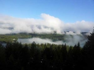
NID System Improvements Coming to Cascade Shores taken May 2012 taken with my cell phone Samsung Galaxy Note

Residents of Cascade Shores east of Nevada City will be getting a larger, more reliable public water system, under actions taken Wednesday (May 23) by the Nevada Irrigation District Board of Directors.

The board voted to purchase 4400 feet of new eight-inch pipeline to replace deteriorating and undersized 4-inch and 6-inch main lines installed in the 1960s and 1970s by the developer of Cascade Shores. The new pipe will be purchased from low bidder Groeniger & Co. for $129,800.

The system improvement is planned along Cascade Loop, Cascade Drive and Artic Close and also includes nine new fire hydrants. NID maintenance crews are slated to begin installing the new pipeline in June.

The overall project is budgeted at $350,000 and is part of a systematic program to upgrade aging water infrastructure in four Nevada County residential communities developed in the 1960s and 1970s. An initial project was completed in Alta Sierra last year, an upgrade is now being completed in Lake of the Pines and an improvement at Lake Wildwood is planned for 2013.

Directors also awarded a $732,600 contract to T&S Construction, Inc. of Sacramento for construction of a new transmission main line along Highway 49 in North Auburn.

The water project will provide for more water and fire flow along the Highway 49 corridor from Locksley Lane to Quartz Drive. Work is expected to begin in June and be completed before winter.

Source: NID press release

John J. O’Dell Realtor® GRI
Civil Engineer
General Contractor
(530) 263-1091
Email jodell@nevadacounty.com

Enhanced by Zemanta

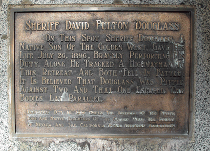
1896 Sheriff David Fulton Douglass is Killed in the Line of Duty

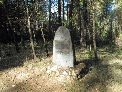
Momument to Sheriff David Fulton Douglass

This monument to Sheriff  David Fulton Douglass is located just off of Airport Road near Nevada City, California.  It lays in the woods all by itself, with no houses nearby.  The monument represents where, on July 26, 1896, Sheriff Douglass, along with a bandit, shot and killed each other.  They are both buried at this spot. The story of what happened on that faithful day is as follows:

David Douglass, Sheriff of Nevada County, California, followed the footprints of two road agents through the underbrush, his big Colt .44 at the ready. Suddenly Douglas stepped into a clearing where, a short distance away, a man was swinging a pistol in his direction.

Douglas was quicker with the .44 and it kicked in his hand as he thumbed off several shots. Hit twice, the man with the revolver fell, mortally wounded.  The date was July 26, 1896, and within seconds, Sheriff Douglass himself would lay dead.

How this all started a few days earlier, William Engle’s freight wagon was held up on the Lake City Road.  Engle turned over $14 to the man. On the 18th, a fruit peddler, traveling the same road, found himself looking down the barrel of a revolver. The view cost him $30.

On July 26th, learning that footprints had been seen not far from Sugar Loaf Mountain, a mile or so behind Nevada City, Douglass drove out in a buggy to check the tracks. He tied the baggy to a tree and started following two sets of footprints.  They led him to the little clearing where he met the man with the revolver, and his own death.

Years later, in 1961 a third man living in Sacramento would confess that he had been the one who killed Sheriff Douglass.

momument-sign-Sheriff-Dougl

Source The Mystery of the “Third Man” American Cowboy


View Larger Map

South Yuba River State Park, Nevada County, California

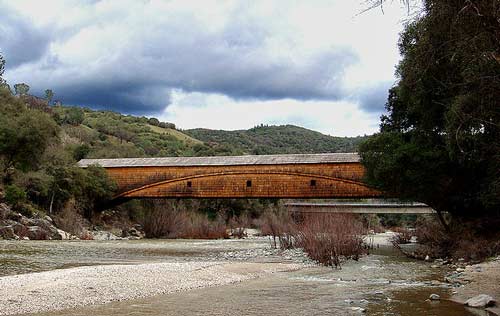
Bridgeport Covered Bridge, Nevada County, CA

The South Yuba River State Park, located in Nevada County,  is a 20-mile portion of the South Yuba River canyon stretching from Malakoff Diggings State Historic Park to Bridgeport covered bridge. The area includes the longest single-span covered bridge in the world, the steep rugged canyon of the South Yuba River, and the Independence Trail — the first identified wheelchair-accessible wilderness trail in the country.

Bridgeport is the centerpiece of the South Yuba River State Park which is one of only nine covered bridges built in the United States prior to 1900. Built in 1862 at 251 feet, it is still the longest single span covered bridge of its type in the United States. One theory as to why bridges were covered is that they were built of wood, and a covered wooden bridge would last longer. The Bridge is a State and National Historic Landmark.
There are many of things to do in the park:

swimming (Including shallow areas where children under family supervision can swim)
hiking
panning for gold
beautiful wildflowers in the spring
exploring the trails leading to historic mining sites
Docent-led history, nature, and gold-panning tours are also offered at selected times throughout the year.

The State of California Park division is offering gold panning lessons and you can log on to their web site at South Yuba River SP for their schedule.

Either Marya Miller or another birder offers a bird hike on the last Sunday of every month at 9:00 AM. Sitting astride the South Yuba River it is the seasonal home to a considerable variety of birds. The wide variety of avian life found throughout the year at Bridgeport is one of its prime attractions. While incomplete, a list would include several varieties of woodpeckers, swallows, owls, wild turkeys, black phoebes, hummingbirds, warblers, wrens, vireos and a wide variety of raptors, including golden and bald eagles.

Adventuresome hikers have a choice of trails ranging in difficulty from the easiest (Independence Trail), to other more strenuous trails throughout the park

South Yuba River State Park headquarters located at Bridgeport, 17660 Pleasant Valley Rd can be accessed from Highway 20 west of Grass Valley or from Higway 49 north of Nevada City. Remote portions of the park are accessible from Edwards Crossing, Purdon Crossing, and Highway 49.


View Larger Map

Lake Spaulding & High Sierra Lakes

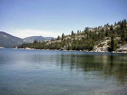
Lake Spaulding
Lake Spaulding

Nevada County has numerous lakes. Most of them are located in the high country between Nevada City and the City of Truckee. Some of these lakes are; Toll house Lake, French Lake, Lake Spaulding, Webber Lake, White Rock Lake and there are more! Many of the lakes were formed by ancient glaciers that are now long gone.

A few of the lakes provide hydroelectric power and is managed by Pacific Gas & Electric. Those owned by P.G.&E are used for hydroelectric power and the company provides camping grounds and picnic facilities. One of these is Lake Spaulding which sits at an elevation of 5,014 feet. It has a surface area of 698 acres surrounded by a high alpine forest. (Google Maps shows Lake Spaulding as Fordyce Creek)

The history of the lake is that it was built for hydraulic mining in 1912. Hydraulic mining generated millions of dollars in tax revenues but was an environmental disaster. Millions of tons of earth and water were delivered to mountain streams that fed rivers flowing into the Sacramento Valley. Once the rivers reached the relatively flat valley, the water slowed, the rivers widened, and the sediment was deposited in the floodplains and river beds causing them to rise, shift to new channels, and overflow their banks, causing major flooding, especially during the spring melt. The end came on January 7, 1884, Judge Lorenzo Sawyer ruled on the matter. – no more dumping of mining debris where it could reach farmlands or navigable rivers.

Lake Spaulding has 25 developed camp sites for tents and RV’s. Boating is allowed, including power, row boats, jet ski, windsurf, canoe, sail, water-ski and inflatable’s. However, check with P.G. & E. before you go up there, since rules and regulations change from time to time. This is also an area for fishing which include brown and rainbow trout. There is also swimming, picnicking, hiking and backpacking.

For reservations and further information, contact P.G.& E. Regional Land Department (916) 386-5164

Let me know if you can add to the above information, use the contact form and I’ll contact you.


View Larger Map

Rollins Lake in Nevada County

rollinslake1

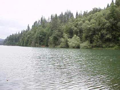
There are many recreational lakes in Nevada County, one of which is Rollins Lake. The lake is located in an unincorporated area called Chicago Park, so called because the first settlers there were first generation Italian-Americans who settled in the area from Chicago.

Rollins Lake is at an elevation of 2,100 feet, surrounded by a forest of pines, oaks and many other species of trees. It has a surface area of 900 acres with 26 miles of shoreline. You can sail or water ski on this lake which has many coves and long stretches of open water. Fishing is allowed, with many species of fish available which include brown trout, catfish, largemouth bass, crappie and bluegill. There is also swimming, picnicking, hiking and riding stables with horseback riding trails.

The boating which allowed on this lake include: power, row, Jet Ski, windsurf, canoe, sail, water ski and inflatable’s. You can also rent fishing boats with motors, canoes and paddle boats. There are four launch ramps, houseboat mooring and a floating gas dock.

rollinslake2

There are 250 developed camping sites for tents and RV’s. There are also full hookups for RV’s and trailer storage along with disposal station and flush toilets.

For further information contact:

Rollins Lake Resort Campground (530) 272-6100
Orchard Springs Campground      (530) 346-2212
Peninsula Campground                  (530) 477-9413
Long Ravine Campground             (530) 346-6166
View Larger Map

Malakoff Diggings State Park

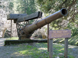
The Hendy Monitor, used to wash the mountains down

With all the bad news lately, it’s time to take a deep breath and think about all of the natural beauties that exist in this County. My friend Judy and I took a trip to Malakoff Diggings a couple of weeks ago. You can go the way we did, from Nevada City on Highway 49, turn right onto North Bloomfield Road, continue on until you come to the park. I prefer this route, with parts of the road steep with many switch backs, cutting across an old bridge over the South Yuba River. You can stop by the bridge and appreciate the wonders of nature and what the force of water can do to a river bed. Then continue on until you get to the park and the town of North Bloomfield.. Interesting, the web site of the State tells you that this route is not recommended. I guess if you are not used to driving in the mountains, it’s not a good way to go, but it is sure a beautiful drive. Google Map

The other way to go, which is a lot faster is to leave Nevada City, travel eleven miles up Highway 49 to left on Tyler Foote Road and continue on to the park. The road changes names several times, but stay on the pavement and you will get there to the park and North Bloomfield.  

Downtown North Bloomfield

Once you get there, there are hiking trails, campgrounds and of course seeing the destruction that the miners seeking gold did to the surrounding mountains. It’s amazing that what was an ecological disaster at the time, has now become a state park. Time has pretty much healed the area with the forest coming back along with the animal life. In the center of the park is the historic town of North Bloomfield. The State has done a really good job of restoring many of the old buildings, and at certain times of the year they are open for you to go in and see what the old miners saw.

Mountain washed down by the miners seeking gold

In 1851 a miner came to town with a pocket full of gold. They followed him to what is now North Bloomfield and could find no gold, so they named the town Humbug. As the town grew to a population of 1,229 people, the residents wanted a post office, so they named the town Bloomfield. However there was another Bloomfield, so they named the town North Bloomfield. The present population is 2-12, I guess depending upon how many rangers are out there, and not counting the bears.

I could go on with the colorful history of the park, but detailed information is available at Wikipedia Malakoff State Historic Park and the website of the California State Parks Website

Take trip up there when the weather is nice, hike, relax, take a nice lunch with you and realize there is more to life then all the negative news we’ve been hearing lately.

Coming to Nevada County

On a rainy night in October, 1968, my family moved to Nevada City from Quincy, CA. My sisters, with me following, explored the old Victorian house in darkness, with lightening striking outside the windows. We opened what we thought was a closet, to find a narrow dark staircase curving up to the second floor. My sister Betsy began making up stories about a murder that had taken place in the back bedroom, just to spook us.

I had started Kindergarten in Quincy, and would continue it in Nevada City. At that time, the classes were in the building between Main and Winter St., just behind the Courthouse. Two of my sisters were in elementary school just up the street, and one was going to Seven Hills School which was on Zion Street, at the time.

Naturally, my memory of that time is mostly visual. I knew nothing of Nevada City and its environs. My experience extended in a triangular area between our first house on Nevada Street (rented) at one point, the Kindergarten yard at another point, and my parent’s print shop on Commercial Street, as the third point. Frankly my memories are not properly sequential, but I remember crossing the freeway at Washington St. I also remember climbing the wall across from the church, and sometimes going up the incredibly (still!) steep Court Street that connects Coyote to Main north of Washington. That winter, ice covered it, and we were nearly late for school trying to get up it. We could have gone around, but it was too much fun!

Through stories told by my parents I learned that Nevada City’s downtown was about half-occupied when we came in 1968. There were several bars, and not much else. I remember Scotch Broom and Grimblefinger Book store (this might have come later) across the street from my parent’s print shop, which was in the building where Mecca is now. It was called DeCrepit Press… With my father’s peculiar sense of humor he had created a “backstory” of the founder being one Lucius Van Der Lewellyn DeCrepit. I remember exploring the space on Commercial St. with it’s brick walls and iron shutters, and mysterious basement with a creek running through it!

As I grew up in Nevada City, I saw many changes. The preservation movement, which turned Nevada City from a run-down, past-its-prime, down-at-the-heels logging town with people longing for the good old days of mining prosperity, to being a historical tourist draw with art and culture aplenty. The burying of the phone and electricity lines and the installation of gaslights and the restoration of the Theatre and Ott’s Assay Office building that created all the momentum… the burst of population growth that followed in the late ‘70’s… There are certainly things I miss, but overall, Nevada City continues to be a truly great place.

I’m hoping a few people who read this will come up with their own memories to share. I’ve got a few more, as well: The first Malakoff homecoming celebrations after the state park was established, the burning of the Torino and the old Carriage house, the Nevada City Independent, and much more.

This post by Richard Webster