Scotts Flat Reservoir seems to be very close to the spillway elevation which is approximately 3074.8 feet in elevation. That’s the elevation in which the water starts flowing out due to increase in volume from rainfall or from release of water from upper dams. As of today, the elevation of the water is 3073 or about 1.8 feet from flowing over the spillway.
In the pictures above, you can see how close to the top of the dam the water is. Camping, fishing, swimming, sunning, boating, water skiing, sailing, board sailing and other activities are popular at Scotts Flat reservoirs in the Sierra foothills. Day use parks, campgrounds and beaches which is operated by a private operator under contract with Nevada Irrigation District.
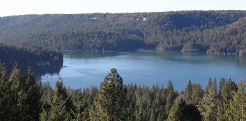
Scotts Flat is situated among the tall pines at the 3100-foot elevation nine miles east of Nevada City via Highway 20 and Scotts Flat Road. It offers 169 campsites at two large campgrounds, plus a group camp. Across the lake, accessible via Red Dog and Quaker Hill Roads from Nevada City, is the Cascade Shores Day Use Area.
For all your real estate needs
Email or call today:
John J. O’Dell Realtor® GRI
Civil Engineer
General Contractor
(530) 263-1091
Email jodell@nevadacounty.com
Captured on four cameras, a nice black marlin off Cairns, Australia jumps and lands aboard the “Little Audrey.” The crew was lucky to escape with only minor injuries and the feisty marlin was released. Little Audrey Game fishing Charters www.littleaudrey.com.au
For all your real estate needs
Email or call today:
John J. O’Dell Realtor® GRI
Civil Engineer
General Contractor
(530) 263-1091
Email <a href=”mailto:jodell@nevadacounty.com”>jodell@nevadacounty.com</a>
This is a video that brought tears to my eyes. The use of fishing nets kills thousands of innocent dolphins, whales and fish every year. At least this whale was saved from a horrible death. This video has had over 2,300,000 views on YouTube.
Emerald Cove Marina – photo courtesy of Emerald Cove Marina
Bullards Bar Reservoir is not in Nevada County, but it is close enough to Nevada City and Grass Valley as to make it a destination for water skiing, house boating and fishing. It’s only 21 miles north of Nevada City off of Highway 49 in the historic gold country. The three closest cities are Nevada City, Grass Valley and Marysville.
The lake surface is at 2,000 foot elevation, 16 miles long with about 60 miles of shoreline. The boating surface is 4,700 acres, which is a lot of area to boat in. There are only two launch ramps and once you are in the water, you are surrounded by a greenbelt covered with pine, oak, fir, madrone, dogwood and other species of trees native to the area. As you cruise up into the North Yuba Canyon, sheer cliffs of granite come down to greet the crystal clear water.
The North Yuba River is backed up by New Bullards Bar Dam which is an awesome sight all by itself. Standing 645? above the canyon floor, it holds back 960,000 acre feet of water. It’s the second tallest dam in California, 5th tallest in the United States. A hydro-electric dam, Bullards Bar Dam is operated and controlled by the Yuba County Water Agency. They are able to manage the water so that recreation access to the reservoir is never restricted.
Bullards Bar offers boat access campgrounds, land based sites, and shoreline camping permits. There are a total of only 160 sites, which limits the amount of people the area can accommodate. Emerald Cove Marina takes site specific reservations for all camping.
For the fisherman, there are kokanee salmon, rainbow trout, German browns, large mouth, small mouth and black bass, crappie, catfish, and bluegill. Bullards Bar has a reputation as having the best kokanee salmon and black bass fishing in California.
CAMPING
Campgrounds – Call for reservations & fees
Pets, NO Hookups, Boat & Trailer Storage, Some Flush Toilets
BOATING
Power, Row, Jet ski, Windsurf, Canoe, Sail, Water-ski, and Inflatables are allowed.
There is a full service marina with gas and propane exchange available
Rentals: Houseboats, Ski Boats, Jet Skis, and Pontoon Patio Boats
RECREATION
Fishing
Swimming, Picnicking, & Hiking
Snacks, Groceries, Bait & Tackle and Fuel Dock
Jeff Toff, a local Grass Valley attorney took a hike around Grouse Ridge with his dog Logan a few weeks ago. Logan is an Irish Wolfhound, and when Logan puts his front feet on Jeff, he’s a lot taller than Jeff. Jeff took many pictures while he was there and I’ve combined them into a video showing how beautiful Grouse Ridge really is.
A beautiful area, it has a geologic display of the 100 million year old birth of the Sierra Nevada Mountains. Just a few thousand years ago, the Rigde was further sculptured by volcanoes and glaciers, leaving over 100 lakes.
Today the story reveals the gentle and slow aging of the region: lakes reverting to meadows and gradual invasion of forests. Within its heart, scattered stands of mature trees offer stark contrast to polished and sculpted granite. Flowers are abundant and beautiful against the massive display of rock.
Grouse Ridge Campground is located approximately 24 miles east of Nevada City at an elevation of 5,600 feet. This campground has 9 walk-in campsites. There is no potable water but toilets are available. There is no trash removal service. Hiking, fishing and swimming are available from this campground.
Information on hiking trails can be found at the Tahoe National Forest website. There are four hiking trails listed. Scroll down towards the bottom of the page to find the information.
Picture courtesy of Camp Far West Lake Campgrounds
Camp Far West Phone Number (530) 633-0803
Camp Far West Reservoir also called Camp Far West Lake, is located at the junction of Placer, Nevada and Yuba counties. Both Beale Air Force Base and the Spenceville Wildlife Area lay directly to the north of the lake. The lake’s location makes it easily accessible by coming from Nevada City, Grass Valley and Western Nevada County along with Sacramento, Roseville or the Yuba City/Marysville area.
Camp Far West’s 185 foot high earth and rock dam was completed in 1963 as part of the Central Valley Water Project impounding water from both the Bear River and Rock Creek. The dam was built for the purpose of flood control and irrigation, but has proven to be a boon for anglers and recreational boaters in the years since.
Camp Far West is situated at an elevation of 280 feet. It is a fairly large lake, impounding 104,500 acre feet of water when at full capacity with a surface area of 2,000 acres and 29 miles of shoreline. The lake got its name from a gold rush era immigrant camp that was located just downstream from the present day dam site. Since it was the last camp on the immigrant trail before the 49ers coming from the east reached the Sacramento Valley, it was dubbed, Camp Far West.
In the spring when the lake is full, the hills are green and the oak trees lining the shoreline are covered with budding leaves, the lake is quite beautiful. In the fall when the water level is drawn down 60 feet or more, the grass is parched and the leaves have fallen, the visual impact isn’t quite as awe inspiring, but the camping and recreation can be just as good as it is early in the year, plus crowds are typically very light during the fall.
Fishes in the lake include largemouth and smallmouth bass, black bass, crappie, catfish, brown trout and striped bass.
Availability: The North Shore is open year-around. The South Shore is open mid-May to September.
Camping and Lodging: Camping facilities and a store are available at the lake. There are 70 campsites on the North Shore and 8 RV hookups. There are 67 campsites on the South Shore and no RV hookups.
Boat Launching: The North Shore and South Shore each has a boat launch ramp and mini marts. The mini marts also include tackle and bait.
Activities: Swimming, boating, water skiing, jet skiing, hiking, biking, fishing and horseback riding
Reservations and Fees: Camp Far West Lake (916) 408-5037 or (530) 633-0803
If you want a nice place to visit and a relatively short drive from Nevada City and Grass Valley then take a journey to Downieville. About forty five miles from Nevada City along scenic Highway 49, it’s a great drive, with a large portion of the trip along the North Fork of the Yuba River. Beautiful views of the river and forest, unsullied by human habitation! A group of us went up there last weekend to get away from it all. And we did!
We stayed at the Downieville River Inn a very nice Bed and Breakfast inn which is run by James & Diane Barnhard. Do not confuse this inn with the one right on Highway 49. I think this one is much quieter, definitely has more grounds and things to do (sauna, swimming pool, BBQ and lawn areas). Diane is a great cook if you come to the morning breakfast. You can even rent houses of various sizes for families who want to cook (or the whole place – there are 12 “units” but the place sleeps 40 people comfortably) for a group gathering or family vacation. Even many or the rooms have a small kitchenette, or refrigerator unit.
After arriving at the inn, we took a one mile hike through town to the twin falls clear on the other side of the town. There are many other hiking trails, and the next day we took another mile hike along the river. Any time you are walking along and come across neighbors or people in the street, you can stop and talk to them. A visit to a restaurant is a time to start meeting the people next to you, where they are from, hobbies, and plans for the day. It is the friendliest town I have been to a long time.
Things to do while you are there includes, fishing, hiking, bicycle riding, there is museum and a couple of nice restaurants. There are numerous bike trails and many sponsored bike rides in the summer. Of course, there is also the natural beauty of the Sierras, with a confluence of the Downie River and the North Yuba River right in the heart of Downieville. When exploring the town, there is no need to drive your car, and the river is easily reachable to sit and just contemplate, or splash your feet.
Convergence of Downie River on the left & Yuba River on the right.
It’s a great little place to visit and it hasn’t changed much from the time I was County Engineer and County Surveyor for Sierra County. When I was up there in the 70’s the population of Sierra County was a little over 3,500 people and now, it’s still a little over 3,500 people! The town has a great gold mining history, stores sell the local gold and jewelry made from it. The town also has a unique history, when in July 1851,lynched a woman, Junita, from the bridge across the North Yuba River for killing a miner.It remains the only lynching of a female in California history.
Sheriffs Gallows Downieville
There is also an original gallows, built in the town and used only, and still there for visitors to see. The gallows, called Sheriff’s Gallows, was constructed in 1885 for the specific execution of nineteen year old James O’Neill, a native of Ireland, who shot and killed his former employer, John Woodward, at Webber Lake, on the afternoon of August 7th.
The northern mines area was populated by a number of gold rush camps with colorful names, places like Brandy City, Whiskey Diggins, Poverty Hill, and Poker Flat. While many of these camps entirely disappeared after the gold rush, Downieville survived due both to its geographical location and status as the seat of Sierra County government
For information on camping, visit Downieville Ranger Station’s Campground Web Site. Also their telephone number is (530) 288-3231
Although Collins Lake Recreational Area is not in Nevada County, it is close enough to our area to be considered a great place to go fishing, boating or camping. Collins Lakes sits at an elevation of 1,200 with a surface area of over 1,000 acres with 12 miles of shoreline.
There are many activities at Collins Lake; which include:
Water skiing, tube or wakeboard are allowed. The water ski season begins May 1st and ends October 15th of each year. However, small, personal watercraft such as jet-skis and small personal watercraft are not permitted to operate on Collins Lake. Boat rentals are available. Of course, swimming is allowed, with the surface temperature of the clear water hovering around 75F to 78F degrees in the summer.
Camping facilities are available, along with cabins in addition to 150 campsites with hookups and 30 campsites without hookups.
Collins Lake Camp Site
The most noted feature of Collins Lake is its fishing. They are raising trophy rainbow trout in underwater net pens during the winter and releasing them in late spring. There are a total of 12 pens, each about the size of a bedroom (12’x 10’x 12′) which is located at the marina. These same trout are expected to triple in size to become 3 to 4 pound trophy-sized fish when released in spring time.
Not only that, they already have California’s largest trout stocking program north of Sacramento and have constructed net pens that will further increase this successful program. For every plant of rainbow trout normally received from Fish and Game, Collins Lake purchases 3 plants of larger trophy sized trout from private hatcheries. In 2007, there were a total of 28,000 pounds of trout planted. The average size of trophy trout planted each week during the spring was 2 to 6 pounds, with some whoppers topping 10 pounds! They are also famous for trophy trout and bass fishing.
For contact information and reservations call 800-286-0576 and locally 530-692-1600
Nevada County has numerous lakes. Most of them are located in the high country between Nevada City and the City of Truckee. Some of these lakes are; Toll house Lake, French Lake, Lake Spaulding, Webber Lake, White Rock Lake and there are more! Many of the lakes were formed by ancient glaciers that are now long gone.
A few of the lakes provide hydroelectric power and is managed by Pacific Gas & Electric. Those owned by P.G.&E are used for hydroelectric power and the company provides camping grounds and picnic facilities. One of these is Lake Spaulding which sits at an elevation of 5,014 feet. It has a surface area of 698 acres surrounded by a high alpine forest. (Google Maps shows Lake Spaulding as Fordyce Creek)
The history of the lake is that it was built for hydraulic mining in 1912. Hydraulic mining generated millions of dollars in tax revenues but was an environmental disaster. Millions of tons of earth and water were delivered to mountain streams that fed rivers flowing into the Sacramento Valley. Once the rivers reached the relatively flat valley, the water slowed, the rivers widened, and the sediment was deposited in the floodplains and river beds causing them to rise, shift to new channels, and overflow their banks, causing major flooding, especially during the spring melt. The end came on January 7, 1884, Judge Lorenzo Sawyer ruled on the matter. – no more dumping of mining debris where it could reach farmlands or navigable rivers.
Lake Spaulding has 25 developed camp sites for tents and RV’s. Boating is allowed, including power, row boats, jet ski, windsurf, canoe, sail, water-ski and inflatable’s. However, check with P.G. & E. before you go up there, since rules and regulations change from time to time. This is also an area for fishing which include brown and rainbow trout. There is also swimming, picnicking, hiking and backpacking.
For reservations and further information, contact P.G.& E. Regional Land Department (916) 386-5164
Let me know if you can add to the above information, use the contact form and I’ll contact you.