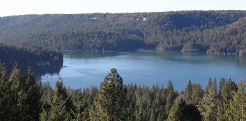
Scotts Flat Reservoir seems to be very close to the spillway elevation which is approximately 3074.8 feet in elevation. That’s the elevation in which the water starts flowing out due to increase in volume from rainfall or from release of water from upper dams. As of today, the elevation of the water is 3073 or about 1.8 feet from flowing over the spillway.
In the pictures above, you can see how close to the top of the dam the water is. Camping, fishing, swimming, sunning, boating, water skiing, sailing, board sailing and other activities are popular at Scotts Flat reservoirs in the Sierra foothills. Day use parks, campgrounds and beaches which is operated by a private operator under contract with Nevada Irrigation District.
Scotts Flat is situated among the tall pines at the 3100-foot elevation nine miles east of Nevada City via Highway 20 and Scotts Flat Road. It offers 169 campsites at two large campgrounds, plus a group camp. Across the lake, accessible via Red Dog and Quaker Hill Roads from Nevada City, is the Cascade Shores Day Use Area.
For all your real estate needs
Email or call today:
John J. O’Dell Realtor® GRI
Civil Engineer
General Contractor
(530) 263-1091
Email jodell@nevadacounty.com
Photo courtesy of Washington Hotel www.washingtonhotel.net
By Judy J. Pinegar
This little town in Nevada County is located on the banks of the South Fork of the Yuba River. It is located off Highway 20 between Nevada City and Interstate 80. Washington boasts a population on about 200, but that fluctuates seasonally and the town has a lot of tourist traffic in the summer.
Washington was founded in 1849, as were most of the cities in Nevada County; it was all about the Gold Rush!! These particular miners were from Indiana, so the settlement was first named Indiana Camp, but renamed to Washington in 1850. The area produced a large amount of placer gold, after that hard rock and hydraulic mines were established and were also very productive. Many people of Chinese descent worked in the area at these times.
The hotel in the town of Washington started with Hessel B. Buisman who was born in Holland in 1827, he landed in San Francisco in 1850. He originally kept a hotel in the town of Jefferson located near Washington from 1852 to 1857. He then came to Washington building a two story hotel which could accommodate up to 30 guests.
After the Buisman owners passed away, their daughter and her husband Eldridge Worthley kept the hotel for years. The hotel was called “The Worthley” or “Washington Hotel” and sat on the same site as the current hotel today. The hotel stable was across the street.
At 11 PM, August 16th, 1867 The Big Fire broke out in a nearby cabin. It jumped from house to house and destroyed almost every business downtown Washington including the Hotel. The hotel was rebuilt.
On April 21st, 1896 another fire started in the kitchen of the Washington Hotel. This fire destroyed the hotel and several buildings nearby. This time, Worthley had taken out fire insurance previous to the fire. The hotel was rebuilt as fast as the weather would allow. The picture shows the new and improved Washington Hotel after being rebuilt in 1896.
Photo courtesy of Washington Hotel www.washingtonhotel.net
The Washington Mining District was always served by operators of small stage lines. This photo shows the company stage of Prescott and Grissel. A daily trip used to leave The National Hotel in Nevada City at 7 AM and arrive in Washington around noon. This was used to rest between trips or take shelter from the weather. Now the drive only takes 25 minutes in your car.
Picture from the Red Ledge Mine in Washington. The gold/quartz veins occur in the sedimentary rocks close to the contact with serpentine. Mariposite is often in association with the serpentine, and in close proximity to the gold. Photo courtesy of http://www.mindat.org/loc-3515.html
The town of Washington currently consists of the Washington Hotel/bar, a restaurant, a grocery store, a one room schoolhouse that has educated students continuously for over 100 years, and two trailer park campgrounds
There are two trailer parks, Gene’s Pine Aire Campground and the River Rest Resort have been in business since the 1960’s with various owners. Campsites are often to capacity, so reservations are advised.
Emerald Cove Marina – photo courtesy of Emerald Cove Marina
Bullards Bar Reservoir is not in Nevada County, but it is close enough to Nevada City and Grass Valley as to make it a destination for water skiing, house boating and fishing. It’s only 21 miles north of Nevada City off of Highway 49 in the historic gold country. The three closest cities are Nevada City, Grass Valley and Marysville.
The lake surface is at 2,000 foot elevation, 16 miles long with about 60 miles of shoreline. The boating surface is 4,700 acres, which is a lot of area to boat in. There are only two launch ramps and once you are in the water, you are surrounded by a greenbelt covered with pine, oak, fir, madrone, dogwood and other species of trees native to the area. As you cruise up into the North Yuba Canyon, sheer cliffs of granite come down to greet the crystal clear water.
The North Yuba River is backed up by New Bullards Bar Dam which is an awesome sight all by itself. Standing 645? above the canyon floor, it holds back 960,000 acre feet of water. It’s the second tallest dam in California, 5th tallest in the United States. A hydro-electric dam, Bullards Bar Dam is operated and controlled by the Yuba County Water Agency. They are able to manage the water so that recreation access to the reservoir is never restricted.
Bullards Bar offers boat access campgrounds, land based sites, and shoreline camping permits. There are a total of only 160 sites, which limits the amount of people the area can accommodate. Emerald Cove Marina takes site specific reservations for all camping.
For the fisherman, there are kokanee salmon, rainbow trout, German browns, large mouth, small mouth and black bass, crappie, catfish, and bluegill. Bullards Bar has a reputation as having the best kokanee salmon and black bass fishing in California.
CAMPING
Campgrounds – Call for reservations & fees
Pets, NO Hookups, Boat & Trailer Storage, Some Flush Toilets
BOATING
Power, Row, Jet ski, Windsurf, Canoe, Sail, Water-ski, and Inflatables are allowed.
There is a full service marina with gas and propane exchange available
Rentals: Houseboats, Ski Boats, Jet Skis, and Pontoon Patio Boats
RECREATION
Fishing
Swimming, Picnicking, & Hiking
Snacks, Groceries, Bait & Tackle and Fuel Dock
Jeff Toff, a local Grass Valley attorney took a hike around Grouse Ridge with his dog Logan a few weeks ago. Logan is an Irish Wolfhound, and when Logan puts his front feet on Jeff, he’s a lot taller than Jeff. Jeff took many pictures while he was there and I’ve combined them into a video showing how beautiful Grouse Ridge really is.
A beautiful area, it has a geologic display of the 100 million year old birth of the Sierra Nevada Mountains. Just a few thousand years ago, the Rigde was further sculptured by volcanoes and glaciers, leaving over 100 lakes.
Today the story reveals the gentle and slow aging of the region: lakes reverting to meadows and gradual invasion of forests. Within its heart, scattered stands of mature trees offer stark contrast to polished and sculpted granite. Flowers are abundant and beautiful against the massive display of rock.
Grouse Ridge Campground is located approximately 24 miles east of Nevada City at an elevation of 5,600 feet. This campground has 9 walk-in campsites. There is no potable water but toilets are available. There is no trash removal service. Hiking, fishing and swimming are available from this campground.
Information on hiking trails can be found at the Tahoe National Forest website. There are four hiking trails listed. Scroll down towards the bottom of the page to find the information.