Tag Archives: Scotts Flat Reservoir

Scotts Flat Reservoir Lake Level September 2014

Scotts Flat Reservoir

Scotts Flat Reservoir
Picture 1 of 9

Scotts Flat Reservoir


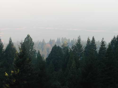
Pictures  by John J. O’Dell from my deck.

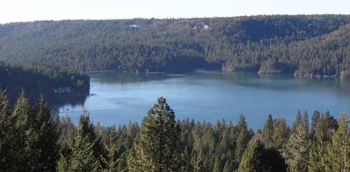
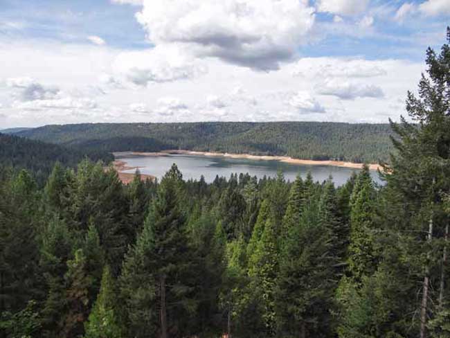
The water level in the lake is down further than I’ve seen since I’ve lived in Cascade Shores, or at least it seems that way.  Scotts Flat Lake or should I say reservoir, what’s the difference?  A lake is a body of water but a  reservoir is different because it’s level is deepest at the dam and some other technicalities . Oh, well, I still like to call it a lake.  If you really want to know the difference between a lake and reservoir go to Lakes & Reservoirs.

If you want to see the projected water level for Scotts Flat Reservoir  that was prepared by Nevada Irrigation District, go to picture 5.  I’m guessing from my pictures and the graph for water levels for Scotts Flat Lake that the present elevation is around 3,036 foot elevation. The high appears to be 3,062  feet in elevation.  That’s a 26 foot drop which cuts the water storage in half, from 40,000 acre feet to 25,000 acre feet. An acre foot is one foot of water over one acre of land or 43,560 cubic feet of water.

Scott’s Flat is situated among the tall pines at the 3100-foot elevation nine miles east of Nevada City via Highway 20 and Scott’s Flat Road. It offers 169 campsites at two large campgrounds, plus a group camp. Across the lake, accessible via Red Dog and Quaker Hill Roads from Nevada City, is the Cascade Shores Day Use Area. As you can see from my pictures, there a lot of trees around the reservoirs, oops lake.

Please help to keep this blog going
Let us Sell or help you buy your new home or land

John J. O’Dell Realtor® GRI
O’Dell Realty
(530) 263-1091
Email John

BRE#00669941

Today the Smoke Over Scotts Flat Lake is Worse


Smoke over Scotts Flat Lake August 13, 2013. Taken from my deck 830 am. Photo Credit John J. O'Dell
Smoke over Scotts Flat Lake August 13, 2013. Taken from my deck 830 am. Photo Credit John J. O’Dell

The smoke over Scotts Flat Lake was even worse this morning than yesterday.  I was smart enough to close my sliding glass doors and turn on the air conditioner during the night. Some of my friends living in Grass Valley  left their windows open and woke up to puffed eyes and sore throats.

The American fire is burning in heavy fuels on very steep slopes. The heavy fuels are creating large amounts of smoke The fire is located about 17 miles northeast of Foresthill in the Tahoe National Forest. Access to the fire is limited adding to the difficulty in fighting this fire. Firefighter safety is a concern.

Fire size is estimated at 1750 acres. The fire has burned across the North Fork Middle Fork American River and is burning both up and down the river drainage. The fire is being actively fought both directly and indirectly.

Multiple Forest Service and Cal Fire personnel are assigned to the fire. Currently 318 resources have been assigned including 18 crews, 16 engines, 4 helicopters, 5 dozers, 4 watertenders, and air tankers as available.

The Central Coast #7 Type II Incident Management Team has assumed managment of the fire.

Smoke is expected to impact Foresthill, Auburn, Nevada City, the valley and other areas for several days.

Please help to keep this blog going
Let us Sell or help you buy your new home or land

John J. O’Dell Realtor® GRI
O’Dell Realty
(530) 263-1091
Email John

DRE#00669941

Enhanced by Zemanta

Scotts Flat Lake January 2013

Image 1 of 5

Scotts Flat Reservoir seems to be very close to the spillway elevation which is approximately 3074.8 feet in elevation. That’s the elevation in which the water starts flowing out due to increase in volume from rainfall or from release of water from upper dams.  As of today, the elevation of the water is 3073 or about 1.8 feet from flowing over the spillway.

In the pictures above, you can see how close to the top of the dam the water is. Camping, fishing, swimming, sunning, boating, water skiing, sailing, board sailing and other activities are popular at  Scotts Flat reservoirs in the Sierra foothills. Day use parks, campgrounds and beaches which is operated by a private operator under contract with Nevada Irrigation District.

Scotts Flat is situated among the tall pines at the 3100-foot elevation nine miles east of Nevada City via Highway 20 and Scotts Flat Road. It offers 169 campsites at two large campgrounds, plus a group camp. Across the lake, accessible via Red Dog and Quaker Hill Roads from Nevada City, is the Cascade Shores Day Use Area.


For all your real estate needs
Email or call today:

John J. O’Dell Realtor® GRI
Civil Engineer
General Contractor
(530) 263-1091
Email jodell@nevadacounty.com

DRE#00669941

View Larger Map

Enhanced by Zemanta